Make a donation
Gear up for your next adventure:
As an Amazon Associate, this site earns from qualifying purchases at no extra cost to you.
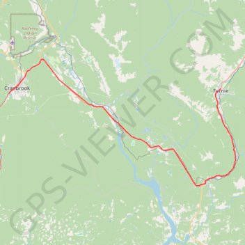
Cranbrook - Fernie
Interactive trail map
Make a donation
Gear up for your next adventure:
As an Amazon Associate, this site earns from qualifying purchases at no extra cost to you.
Trail profile
- Distance: 62.3 mi
- Elevation gain: 2,520 ft
- Maximum elevation: 3,294 ft
- Elevation loss: 2,257 ft
- Minimum elevation: 2,448 ft
Make a donation
Gear up for your next adventure:
As an Amazon Associate, this site earns from qualifying purchases at no extra cost to you.
About this trail
Name: Cranbrook - Fernie trail, distance, elevation, map, profile, GPS track
Coordinates: 49.29037 -115.79441 49.57481 -115.01032
Make a donation
Gear up for your next adventure:
As an Amazon Associate, this site earns from qualifying purchases at no extra cost to you.
Other hiking, mountain biking, running and outdoor activity trails
Click on a trail to view its statistics, map and profile.
Fairy Creek Waterfall Trail
Canada > British Columbia > Regional District of East Kootenay > Fernie
#Hiking #MTB #Snowshoeing #Forest #Falls
Distance: 2.8 mi • Elevation gain: 486 ft • Maximum elevation: 3,553 ft
Bike trail in Cranbrook Community Forest BC
Canada > British Columbia > Regional District of East Kootenay > Area C (Moyie/Bull River)
Distance: 7.8 mi • Elevation gain: 886 ft • Maximum elevation: 3,219 ft
Make a donation
Gear up for your next adventure:
As an Amazon Associate, this site earns from qualifying purchases at no extra cost to you.