Sol Duc Falls Trail in Olympic National Park
The Sol Duc Falls Trail in Olympic National Park offers an enchanting journey through lush, moss-draped old-growth forests, leading to the stunning Sol Duc Falls, where water cascades gracefully into a narrow gorge. Along the well-maintained path, hikers traverse charming wooden bridges over clear streams and may encounter vibrant wildflowers, especially in spring. The trail's gentle terrain makes it accessible for all fitness levels, providing an immersive Pacific Northwest rainforest experience. #Hiking #Waterfall #Forest #River #Nature
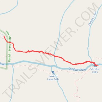
- Distance: 1.7 mi
- Elevation gain: 272 ft
- Maximum elevation: 2,083 ft
- Elevation loss: 272 ft
- Minimum elevation: 1,942 ft
- Moving time: 44 m 46 s
- Moving speed: 2.3 mph
- Maximum speed: 4.7 mph
- Total time: 46 m 8 s
- Global speed: 2.3 mph
Interactive trail map
Trail profile
- Distance: 1.7 mi
- Elevation gain: 272 ft
- Maximum elevation: 2,083 ft
- Elevation loss: 272 ft
- Minimum elevation: 1,942 ft
- Moving time: 44 m 46 s
- Moving speed: 2.3 mph
- Maximum speed: 4.7 mph
- Total time: 46 m 8 s
- Global speed: 2.3 mph
About this trail
Name: Sol Duc Falls Trail in Olympic National Park trail, distance, elevation, map, profile, GPS track
Coordinates: 47.95171 -123.83483 47.95493 -123.81930
Topography: Clallam County topographic map, elevation, terrain
Other hiking, mountain biking, running and outdoor activity trails
Click on a trail to view its statistics, map and profile.
Deer Lake Trail via Sol Duc Falls
United States > Washington > Clallam County
Distance: 2.5 mi • Elevation gain: 1,211 ft • Maximum elevation: 3,051 ft