
Eine Runde über Feigenbaumklippe
Angenehmes Kennenlernen, Harz (Landkreis Goslar), gemeindefreies Gebiet. Diese Route führt entlang der schönsten Wege durch Kästeklippen. Entdecken Sie die Region entlang unbefestigter Wege. Eine Route, die Sie sicher bezaubern wird.
- Distance: 6.2 mi
- Elevation gain: 1,430 ft
- Maximum elevation: 1,936 ft
- Elevation loss: 1,430 ft
- Minimum elevation: 1,020 ft
Interactive trail map
Trail profile
- Distance: 6.2 mi
- Elevation gain: 1,430 ft
- Maximum elevation: 1,936 ft
- Elevation loss: 1,430 ft
- Minimum elevation: 1,020 ft
About this trail
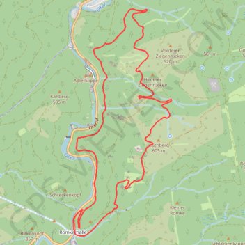
Name: Eine Runde über Feigenbaumklippe trail, distance, elevation, map, profile, GPS track
Coordinates: 51.85835 10.47125 51.88458 10.48961
Other hiking, mountain biking, running and outdoor activity trails
Click on a trail to view its statistics, map and profile.
Görlitz - Alpen
Germany > Saxony > Görlitz > Görlitz
Distance: 465.7 mi • Elevation gain: 16,929 ft • Maximum elevation: 1,463 ft
Görlitz - Alpen
Germany > Saxony > Görlitz > Görlitz
Distance: 465.7 mi • Elevation gain: 16,929 ft • Maximum elevation: 1,463 ft