Make a donation
Gear up for your next adventure:
As an Amazon Associate, this site earns from qualifying purchases at no extra cost to you.
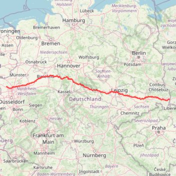
Görlitz - Alpen
- Distance: 465.7 mi
- Elevation gain: 16,929 ft
- Maximum elevation: 1,463 ft
- Elevation loss: 17,566 ft
- Minimum elevation: 59 ft
Interactive trail map
Make a donation
Gear up for your next adventure:
As an Amazon Associate, this site earns from qualifying purchases at no extra cost to you.
Trail profile
- Distance: 465.7 mi
- Elevation gain: 16,929 ft
- Maximum elevation: 1,463 ft
- Elevation loss: 17,566 ft
- Minimum elevation: 59 ft
Make a donation
Gear up for your next adventure:
As an Amazon Associate, this site earns from qualifying purchases at no extra cost to you.
About this trail
Name: Görlitz - Alpen trail, distance, elevation, map, profile, GPS track
Start: 25, Rauschwalder Straße, Innenstadt, Görlitz, Saxony, 02826, Germany (51.15225 14.96788)
Coordinates: 51.12562 6.51386 51.93394 14.96788
Make a donation
Gear up for your next adventure:
As an Amazon Associate, this site earns from qualifying purchases at no extra cost to you.
Other hiking, mountain biking, running and outdoor activity trails
Click on a trail to view its statistics, map and profile.
Fledermauswald
Germany > North Rhine-Westphalia > Kreis Warendorf > Ennigerloh > Westkirchen
Loop from Ennigerloh.
Distance: 31.0 mi • Elevation gain: 374 ft • Maximum elevation: 272 ft
Hoeveler Strasse, Hamm - Mansfelder Strasse 64, Hamm
Germany > North Rhine-Westphalia > Hamm
Loop from Hamm.
Distance: 20.2 mi • Elevation gain: 482 ft • Maximum elevation: 318 ft
Görlitz - Alpen
Germany > Saxony > Görlitz > Görlitz
Distance: 465.7 mi • Elevation gain: 16,929 ft • Maximum elevation: 1,463 ft
Weser-Radweg on GPSies.com
Germany > Lower Saxony > Landkreis Göttingen > Hann. Münden
Distance: 245.5 mi • Elevation gain: 8,012 ft • Maximum elevation: 705 ft
Make a donation
Gear up for your next adventure:
As an Amazon Associate, this site earns from qualifying purchases at no extra cost to you.
Track vom: 2020-06-13 07:00
Germany > North Rhine-Westphalia > Kreis Wesel > Schermbeck
Distance: 422.5 mi • Elevation gain: 17,392 ft • Maximum elevation: 3,022 ft
Track vom: 2020-06-27 07:26
Germany > Bavaria > Landkreis Ostallgäu > Halblech
Distance: 427.6 mi • Elevation gain: 14,131 ft • Maximum elevation: 2,989 ft
Riethoven naar Oostenrijk
Netherlands > North Brabant > Riethoven > Eind
Distance: 573.0 mi • Elevation gain: 44,715 ft • Maximum elevation: 6,224 ft
Eine Runde über Feigenbaumklippe
Germany > Lower Saxony > Landkreis Goslar > Harz (LK Goslar)
Angenehmes Kennenlernen, Harz (Landkreis Goslar), gemeindefreies Gebiet. Diese Route führt entlang der schönsten Wege durch Kästeklippen. Entdecken Sie die Region entlang unbefestigter Wege. Eine Route, die Sie sicher bezaubern wird.
Distance: 6.2 mi • Elevation gain: 1,430 ft • Maximum elevation: 1,936 ft
Make a donation
Gear up for your next adventure:
As an Amazon Associate, this site earns from qualifying purchases at no extra cost to you.
Eurovelo 15 - Strasbourg Rotterdam
France > Grand Est > Bas-Rhin > Strasbourg
Distance: 554.1 mi • Elevation gain: 6,903 ft • Maximum elevation: 479 ft
PT23BS1 Kiel → Lörrach
Germany > Schleswig-Holstein > Kiel
Distance: 650.4 mi • Elevation gain: 30,397 ft • Maximum elevation: 2,484 ft
Unnamed
Germany > North Rhine-Westphalia > Ennepe-Ruhr-Kreis > Gevelsberg
Distance: 83.6 mi • Elevation gain: 7,251 ft • Maximum elevation: 1,450 ft
Divided from: Zeopoxa Cycling
Poland > Lower Silesian Voivodeship > Zgorzelec County > Zgorzelec
Distance: 106.9 mi • Elevation gain: 5,876 ft • Maximum elevation: 1,798 ft
Make a donation
Gear up for your next adventure:
As an Amazon Associate, this site earns from qualifying purchases at no extra cost to you.