
Hanakapi'ai Falls via Kalalau Trail and Hanakapi'ai Trail in Nā Pali Coast State Wilderness Park
The hike to Hanakapi'ai Falls is a challenging yet rewarding adventure along Kaua'i’s Nā Pali Coast. Starting from Ke’e Beach, the trail offers a mix of sweeping ocean views and dramatic cliffs, leading you through dense vegetation, bamboo groves, and occasional stream crossings. As you get closer to the falls, the path becomes steeper and muddier, testing your balance and endurance before you are finally rewarded with the sight of the 400-foot waterfall nestled within a lush valley. Though the trail’s rugged terrain and unpredictable weather can make it difficult, the stunning vistas and cool waters at the falls make the effort worthwhile. #Hiking #Waterfall #Forest #Beach #Sea #Pacific #Ocean #Nature #Mountain #Volcano #Island #Hawaii
- Distance: 7.9 mi
- Elevation gain: 3,655 ft
- Maximum elevation: 1,309 ft
- Elevation loss: 3,671 ft
- Minimum elevation: 46 ft
Interactive trail map
Trail profile
- Distance: 7.9 mi
- Elevation gain: 3,655 ft
- Maximum elevation: 1,309 ft
- Elevation loss: 3,671 ft
- Minimum elevation: 46 ft
About this trail
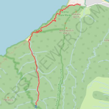
Name: Hanakapi'ai Falls via Kalalau Trail and Hanakapi'ai Trail in Nā Pali Coast State Wilderness Park trail, distance, elevation, map, profile, GPS track
Start: Kuhio Highway, Kauaʻi County, Hawaii, United States (22.22070 -159.57857)
End: Ke'e Beach Parking Lot, Kuhio Highway, Kauaʻi County, Hawaii, United States (22.22076 -159.57834)
Coordinates: 22.18618 -159.59763 22.22095 -159.57834
Topography: Kauaʻi County topographic map, elevation, terrain
Other hiking, mountain biking, running and outdoor activity trails
Click on a trail to view its statistics, map and profile.
Hanakapi'ai Falls (Kauai Island)
United States > Hawaii > Kauaʻi County
Starting at Kēʻē Beach in Hāʻena State Park, this out-and-back hike follows the Kalalau Trail above the Pacific, leaving the coastal edge of the park to reveal the first broad views of the Nā Pali Coast, with ocean, reef, sea cliffs, and tropical vegetation appearing in succession along the way. The…
Distance: 7.9 mi • Elevation gain: 3,871 ft • Maximum elevation: 1,342 ft
Kalalau Trail to Hoolea Falls (Kauai Island)
United States > Hawaii > Kauaʻi County
Hike from Ka'ilio Point to Hoolea Falls via Kalalau Trail, Ha'ena State Park, Na Pali Coast State Wilderness Park, The Gate, Hono o Na Pali Natural Area Reserve and Kalalau Beach. #Hiking #Coast #Sea #Pacific #Ocean #Nature #Beach #Forest #Mountain #Volcano #Island #Hawaii
Distance: 19.0 mi • Elevation gain: 9,938 ft • Maximum elevation: 735 ft