Durham
- Distance: 16.4 mi
- Elevation gain: 1,470 ft
- Maximum elevation: 2,024 ft
- Elevation loss: 1,473 ft
- Minimum elevation: 1,699 ft
- Moving time: 1 h 25 m
- Moving speed: 11.6 mph
- Maximum speed: 22.5 mph
- Total time: 1 h 26 m
- Global speed: 11.4 mph
Interactive trail map
Trail profile
- Distance: 16.4 mi
- Elevation gain: 1,470 ft
- Maximum elevation: 2,024 ft
- Elevation loss: 1,473 ft
- Minimum elevation: 1,699 ft
- Moving time: 1 h 25 m
- Moving speed: 11.6 mph
- Maximum speed: 22.5 mph
- Total time: 1 h 26 m
- Global speed: 11.4 mph
About this trail
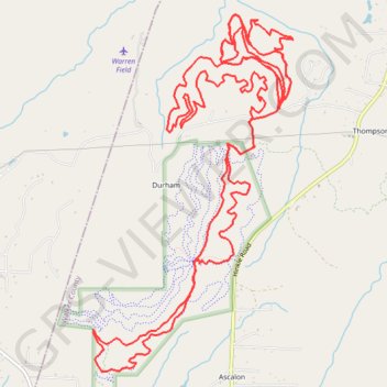
Name: Durham trail, distance, elevation, map, profile, GPS track
Start: Access Trail, Walker County, Georgia, United States (34.86579 -85.41895)
End: Access Trail, Walker County, Georgia, United States (34.86550 -85.41904)
Coordinates: 34.83996 -85.44102 34.87466 -85.41737
Topography: Walker County topographic map, elevation, terrain
Other hiking, mountain biking, running and outdoor activity trails
Click on a trail to view its statistics, map and profile.
Cloudland to Ross Landing
United States > Georgia > Dade County
River to Clouds Route
Distance: 34.4 mi • Elevation gain: 3,635 ft • Maximum elevation: 2,057 ft