Make a donation
Gear up for your next adventure:
As an Amazon Associate, this site earns from qualifying purchases at no extra cost to you.
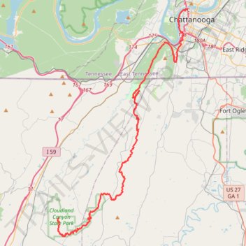
Cloudland to Ross Landing
River to Clouds Route
- Distance: 34.4 mi
- Elevation gain: 3,635 ft
- Maximum elevation: 2,057 ft
- Elevation loss: 4,633 ft
- Minimum elevation: 646 ft
Interactive trail map
Make a donation
Gear up for your next adventure:
As an Amazon Associate, this site earns from qualifying purchases at no extra cost to you.
Trail profile
- Distance: 34.4 mi
- Elevation gain: 3,635 ft
- Maximum elevation: 2,057 ft
- Elevation loss: 4,633 ft
- Minimum elevation: 646 ft
Make a donation
Gear up for your next adventure:
As an Amazon Associate, this site earns from qualifying purchases at no extra cost to you.
About this trail
Name: Cloudland to Ross Landing trail, distance, elevation, map, profile, GPS track
Start: Overlook Trail, Dade County, Georgia, 30738, United States (34.83594 -85.47969)
Coordinates: 34.81718 -85.48123 35.05590 -85.31413
Topography: Dade County topographic map, elevation, terrain
Make a donation
Gear up for your next adventure:
As an Amazon Associate, this site earns from qualifying purchases at no extra cost to you.
Other hiking, mountain biking, running and outdoor activity trails
Click on a trail to view its statistics, map and profile.
Cloudland Canyon West Rim Loop Trail
United States > Georgia > Dade County
The West Rim Loop Trail at Cloudland Canyon State Park offers hikers breathtaking vistas of the expansive canyon, with its rugged cliffs and dense forests. As the trail meanders along the canyon's edge, it provides multiple overlooks that showcase the park's diverse landscapes, including panoramic views of the…
Distance: 4.9 mi • Elevation gain: 1,063 ft • Maximum elevation: 1,913 ft
Cloudland Canyon West Rim Loop Trail
United States > Georgia > Dade County
The Cloudland Canyon West Rim Loop Trail offers hikers a captivating journey through diverse landscapes. Along the route, visitors are treated to sweeping views of the rugged canyon, with numerous overlooks providing glimpses of the deep gorges and distant valleys. The trail meanders through dense woodlands…
Distance: 4.9 mi • Elevation gain: 1,007 ft • Maximum elevation: 1,913 ft
Loop hike to Glen Falls
United States > Tennessee > Hamilton County > Chattanooga > Saint Elmo
Distance: 5.2 mi • Elevation gain: 1,365 ft • Maximum elevation: 1,512 ft
Make a donation
Gear up for your next adventure:
As an Amazon Associate, this site earns from qualifying purchases at no extra cost to you.
Durham
United States > Georgia > Walker County
Distance: 16.4 mi • Elevation gain: 1,470 ft • Maximum elevation: 2,024 ft