Make a donation
Gear up for your next adventure:
As an Amazon Associate, this site earns from qualifying purchases at no extra cost to you.
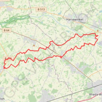
Fledermauswald
Loop from Ennigerloh.
- Distance: 31.0 mi
- Elevation gain: 374 ft
- Maximum elevation: 272 ft
- Elevation loss: 374 ft
- Minimum elevation: 200 ft
Interactive trail map
Make a donation
Gear up for your next adventure:
As an Amazon Associate, this site earns from qualifying purchases at no extra cost to you.
Trail profile
- Distance: 31.0 mi
- Elevation gain: 374 ft
- Maximum elevation: 272 ft
- Elevation loss: 374 ft
- Minimum elevation: 200 ft
Make a donation
Gear up for your next adventure:
As an Amazon Associate, this site earns from qualifying purchases at no extra cost to you.
About this trail
Name: Fledermauswald trail, distance, elevation, map, profile, GPS track
Coordinates: 51.88340 8.04303 51.93921 8.28581
Make a donation
Gear up for your next adventure:
As an Amazon Associate, this site earns from qualifying purchases at no extra cost to you.
Other hiking, mountain biking, running and outdoor activity trails
Click on a trail to view its statistics, map and profile.
Görlitz - Alpen
Germany > Saxony > Görlitz > Görlitz
Distance: 465.7 mi • Elevation gain: 16,929 ft • Maximum elevation: 1,463 ft
Görlitz - Alpen
Germany > Saxony > Görlitz > Görlitz
Distance: 465.7 mi • Elevation gain: 16,929 ft • Maximum elevation: 1,463 ft
Eurovelo 15 - Strasbourg Rotterdam
France > Grand Est > Bas-Rhin > Strasbourg
Distance: 554.1 mi • Elevation gain: 6,903 ft • Maximum elevation: 479 ft
PT23BS1 Kiel → Lörrach
Germany > Schleswig-Holstein > Kiel
Distance: 650.4 mi • Elevation gain: 30,397 ft • Maximum elevation: 2,484 ft
Make a donation
Gear up for your next adventure:
As an Amazon Associate, this site earns from qualifying purchases at no extra cost to you.