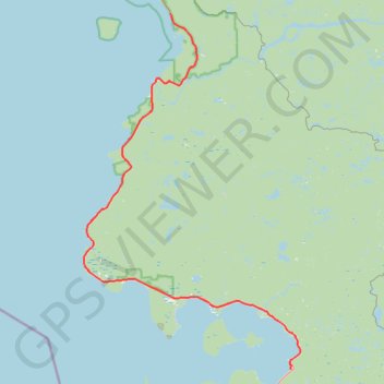
Lake Superior Provincial Park - Harmony Beach
- Distance: 58.5 mi
- Elevation gain: 3,009 ft
- Maximum elevation: 1,270 ft
- Elevation loss: 3,018 ft
- Minimum elevation: 591 ft
Interactive trail map
Trail profile
- Distance: 58.5 mi
- Elevation gain: 3,009 ft
- Maximum elevation: 1,270 ft
- Elevation loss: 3,018 ft
- Minimum elevation: 591 ft
About this trail
Name: Lake Superior Provincial Park - Harmony Beach trail, distance, elevation, map, profile, GPS track
Coordinates: 46.84601 -84.78755 47.33142 -84.35312
Other hiking, mountain biking, running and outdoor activity trails
Click on a trail to view its statistics, map and profile.
Wawa - Lake Superior Provincial Park
Canada > Ontario > Algoma District > Wawa
#Bike #Wawa #LakeSuperior
Distance: 55.5 mi • Elevation gain: 2,920 ft • Maximum elevation: 1,339 ft