Mount Greylock
From the Greylock Glen trailhead, the hike first follows the Glen Meadow Loop through open meadow, wetland edges and woodland, with Mount Greylock rising ahead as the route leaves the gentler Glen paths for the Bellows Pipe approach.
The climb then moves into denser forest on Bellows Pipe and toward the historic Thunderbolt Ski Trail, a steeper old ski line that cuts up the eastern side of the mountain through rocky, ferny terrain.
Near the crest, the route joins the Appalachian Trail and finishes at Mount Greylock’s summit area, where Bascom Lodge, the Massachusetts Veterans War Memorial Tower and wide Berkshire views provide a memorable high-point arrival.
#Hiking #Mountain #Nature #Forest #Appalachian #Summit #Meadow
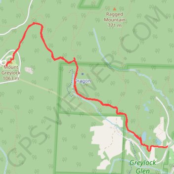
- Distance: 5.6 mi
- Elevation gain: 2,392 ft
- Maximum elevation: 3,484 ft
- Elevation loss: 2,398 ft
- Minimum elevation: 1,155 ft
- Moving time: 3 h 23 m
- Moving speed: 1.6 mph
- Maximum speed: 3.0 mph
- Total time: 4 h 36 m
- Global speed: 1.2 mph
Interactive trail map
Trail profile
- Distance: 5.6 mi
- Elevation gain: 2,392 ft
- Maximum elevation: 3,484 ft
- Elevation loss: 2,398 ft
- Minimum elevation: 1,155 ft
- Moving time: 3 h 23 m
- Moving speed: 1.6 mph
- Maximum speed: 3.0 mph
- Total time: 4 h 36 m
- Global speed: 1.2 mph
About this trail
Name: Mount Greylock trail, distance, elevation, map, profile, GPS track
Start: 110, Gould Road, Adams, Berkshire County, Massachusetts, 01220, United States (42.62596 -73.13752)
End: 113, Gould Road, Adams, Berkshire County, Massachusetts, 01220, United States (42.62579 -73.13772)
Coordinates: 42.62531 -73.16682 42.64248 -73.13752
Topography: Berkshire County topographic map, elevation, terrain
Other hiking, mountain biking, running and outdoor activity trails
Click on a trail to view its statistics, map and profile.
Mount Greylock via Bellows Pipe Trail in Mount Greylock State Reservation
United States > Massachusetts > Berkshire County > Adams
The Bellows Pipe Trail on Mount Greylock provides a scenic ascent through dense forests, culminating in stunning summit views. Hikers pass through lush hardwood groves, a segment of the Appalachian Trail, and reach the iconic Veterans War Memorial Tower, which offers expansive vistas of the surrounding…
Distance: 5.7 mi • Elevation gain: 2,241 ft • Maximum elevation: 3,484 ft