Mount Greylock via Bellows Pipe Trail in Mount Greylock State Reservation
The Bellows Pipe Trail on Mount Greylock provides a scenic ascent through dense forests, culminating in stunning summit views. Hikers pass through lush hardwood groves, a segment of the Appalachian Trail, and reach the iconic Veterans War Memorial Tower, which offers expansive vistas of the surrounding Berkshires and glimpses into neighboring states on clear days. The trail's combination of natural beauty and cultural landmarks makes it a rewarding choice for those looking to experience New England’s highest point. #Hiking #Mountain #Forest #Nature
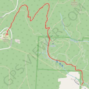
- Distance: 5.7 mi
- Elevation gain: 2,241 ft
- Maximum elevation: 3,484 ft
- Elevation loss: 2,241 ft
- Minimum elevation: 1,243 ft
- Moving time: 3 h 1 m
- Moving speed: 1.9 mph
- Maximum speed: 4.4 mph
- Total time: 3 h 33 m
- Global speed: 1.6 mph
Interactive trail map
Trail profile
- Distance: 5.7 mi
- Elevation gain: 2,241 ft
- Maximum elevation: 3,484 ft
- Elevation loss: 2,241 ft
- Minimum elevation: 1,243 ft
- Moving time: 3 h 1 m
- Moving speed: 1.9 mph
- Maximum speed: 4.4 mph
- Total time: 3 h 33 m
- Global speed: 1.6 mph
About this trail
Name: Mount Greylock via Bellows Pipe Trail in Mount Greylock State Reservation trail, distance, elevation, map, profile, GPS track
End: Gould Road, Adams, Berkshire County, Massachusetts, 01220, United States (42.62715 -73.14517)
Coordinates: 42.62715 -73.16600 42.64383 -73.14463
Topography: Berkshire County topographic map, elevation, terrain
Other hiking, mountain biking, running and outdoor activity trails
Click on a trail to view its statistics, map and profile.
Mount Greylock
United States > Massachusetts > Berkshire County > Adams
From the Greylock Glen trailhead, the hike first follows the Glen Meadow Loop through open meadow, wetland edges and woodland, with Mount Greylock rising ahead as the route leaves the gentler Glen paths for the Bellows Pipe approach. The climb then moves into denser forest on Bellows Pipe and toward the…
Distance: 5.6 mi • Elevation gain: 2,392 ft • Maximum elevation: 3,484 ft