Munro Hillwalk Sgurr Coireachan Sgurr Thuilm
Munro, Hillwalk, Sgurr, Coireachan, Sgurr, Thuilm
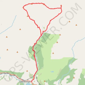
- Distance: 16.4 mi
- Elevation gain: 4,767 ft
- Maximum elevation: 3,143 ft
- Elevation loss: 4,764 ft
- Minimum elevation: 10 ft
Interactive trail map
Trail profile
- Distance: 16.4 mi
- Elevation gain: 4,767 ft
- Maximum elevation: 3,143 ft
- Elevation loss: 4,764 ft
- Minimum elevation: 10 ft
About this trail
Name: Munro Hillwalk Sgurr Coireachan Sgurr Thuilm trail, distance, elevation, map, profile, GPS track
Coordinates: 56.87079 -5.44880 56.93883 -5.38802
Other hiking, mountain biking, running and outdoor activity trails
Click on a trail to view its statistics, map and profile.
Hike from Glenfinnan to A Chùil
United Kingdom > Scotland > Highland > Glenfinnan
Distance: 12.6 mi • Elevation gain: 2,451 ft • Maximum elevation: 1,634 ft