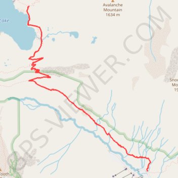
Snow Lake
Interactive trail map
Trail profile
- Distance: 6.7 mi
- Elevation gain: 1,860 ft
- Maximum elevation: 4,350 ft
- Elevation loss: 1,860 ft
- Minimum elevation: 3,136 ft
About this trail
Name: Snow Lake trail, distance, elevation, map, profile, GPS track
Start: Snow Lake Trail, King County, Washington, 98068, United States (47.44542 -121.42353)
End: Snow Lake Trail, King County, Washington, 98068, United States (47.44542 -121.42353)
Coordinates: 47.44542 -121.44849 47.46853 -121.42282
Topography: King County topographic map, elevation, terrain
Other hiking, mountain biking, running and outdoor activity trails
Click on a trail to view its statistics, map and profile.
Melakwa Lake via Denny Creek Trail in Alpine Lakes Wilderness
United States > Washington > King County
The Melakwa Lake via Denny Creek Trail offers a captivating journey through the Alpine Lakes Wilderness. The route begins in lush forested areas, where hikers can enjoy views of cascading waterfalls, including the dramatic Keekwulee Falls, before ascending to rocky and open terrain. The trail culminates at…
Distance: 8.7 mi • Elevation gain: 2,838 ft • Maximum elevation: 4,649 ft
Snow Lake Trail in Alpine Lakes Wilderness
United States > Washington > King County
The Snow Lake Trail is a scenic and moderately challenging hike that rewards adventurers with breathtaking views of the lake and surrounding mountains. Starting from the Alpental Ski Area, the trail features a series of switchbacks that ascend through dense forests, eventually revealing panoramic vistas of the…
Distance: 6.1 mi • Elevation gain: 1,785 ft • Maximum elevation: 4,344 ft
Snow Lake Trail in Alpine Lakes Wilderness
United States > Washington > King County
The Snow Lake Trail offers a scenic and moderate hike with expansive views of both lush forests and striking mountain landscapes. Hikers are treated to vistas of the sparkling blue waters of Snow Lake, framed by the towering peaks of Chair Peak and other nearby summits, which provide a stunning backdrop…
Distance: 6.0 mi • Elevation gain: 1,706 ft • Maximum elevation: 4,344 ft
Northern part of the Pacific Crest Trail (PCT)
United States > Oregon > Klamath County
Hike on the Pacific Crest National Scenic Trail from Crater Lake to Canada Border through Oregon and Washington along the Sierra Nevada and Cascade mountain ranges. #Hiking #Mountain #SierraNevada #Cascade #Nature #Forest #Park #PCT
Distance: 744.6 mi • Elevation gain: 145,367 ft • Maximum elevation: 7,569 ft