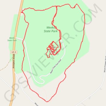
Hiking trails at Weeks State Park
- Distance: 6.1 mi
- Elevation gain: 1,135 ft
- Maximum elevation: 2,041 ft
- Elevation loss: 1,125 ft
- Minimum elevation: 1,371 ft
- Moving time: 3 h 26 m
- Moving speed: 1.8 mph
- Maximum speed: 6.9 mph
- Total time: 4 h 23 m
- Global speed: 1.4 mph
Interactive trail map
Trail profile
- Distance: 6.1 mi
- Elevation gain: 1,135 ft
- Maximum elevation: 2,041 ft
- Elevation loss: 1,125 ft
- Minimum elevation: 1,371 ft
- Moving time: 3 h 26 m
- Moving speed: 1.8 mph
- Maximum speed: 6.9 mph
- Total time: 4 h 23 m
- Global speed: 1.4 mph
About this trail
Name: Hiking trails at Weeks State Park trail, distance, elevation, map, profile, GPS track
Coordinates: 44.44333 -71.57697 44.45820 -71.56345
Topography: Coos County topographic map, elevation, terrain
Other hiking, mountain biking, running and outdoor activity trails
Click on a trail to view its statistics, map and profile.