Thank you for supporting this site ❤️
Make a donation
Make a donation
Gear up for your next adventure:
As an Amazon Associate, this site earns from qualifying purchases at no extra cost to you.
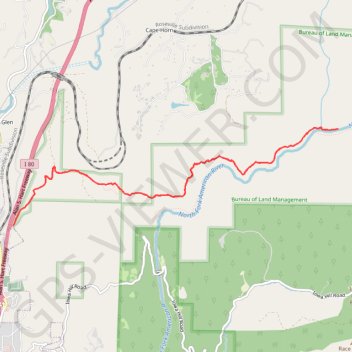
North Fork American River via Stevens Trail
Interactive trail map
Thank you for supporting this site ❤️
Make a donation
Make a donation
Gear up for your next adventure:
As an Amazon Associate, this site earns from qualifying purchases at no extra cost to you.
Trail profile
- Distance: 7.7 mi
- Elevation gain: 2,126 ft
- Maximum elevation: 2,382 ft
- Elevation loss: 2,126 ft
- Minimum elevation: 1,224 ft
Thank you for supporting this site ❤️
Make a donation
Make a donation
Gear up for your next adventure:
As an Amazon Associate, this site earns from qualifying purchases at no extra cost to you.
About this trail
Name: North Fork American River via Stevens Trail trail, distance, elevation, map, profile, GPS track
Coordinates: 39.10545 -120.94736 39.11732 -120.89667
Topography: Placer County topographic map, elevation, terrain
Thank you for supporting this site ❤️
Make a donation
Make a donation
Gear up for your next adventure:
As an Amazon Associate, this site earns from qualifying purchases at no extra cost to you.