Thank you for supporting this site ❤️
Make a donation
Make a donation
Gear up for your next adventure:
As an Amazon Associate, this site earns from qualifying purchases at no extra cost to you.
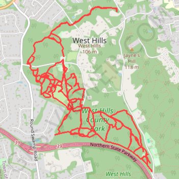
West Hills County Park
- Distance: 16.8 mi
- Elevation gain: 1,247 ft
- Maximum elevation: 367 ft
- Elevation loss: 1,319 ft
- Minimum elevation: 157 ft
- Moving time: 6 h 10 m
- Moving speed: 2.7 mph
- Maximum speed: 5.6 mph
- Total time: 9 d 1 h
- Global speed: 0.1 mph
Interactive trail map
Thank you for supporting this site ❤️
Make a donation
Make a donation
Gear up for your next adventure:
As an Amazon Associate, this site earns from qualifying purchases at no extra cost to you.
Trail profile
- Distance: 16.8 mi
- Elevation gain: 1,247 ft
- Maximum elevation: 367 ft
- Elevation loss: 1,319 ft
- Minimum elevation: 157 ft
- Moving time: 6 h 10 m
- Moving speed: 2.7 mph
- Maximum speed: 5.6 mph
- Total time: 9 d 1 h
- Global speed: 0.1 mph
Thank you for supporting this site ❤️
Make a donation
Make a donation
Gear up for your next adventure:
As an Amazon Associate, this site earns from qualifying purchases at no extra cost to you.
About this trail
Name: West Hills County Park trail, distance, elevation, map, profile, GPS track
Coordinates: 40.79907 -73.44306 40.82059 -73.42167
Topography: Suffolk County topographic map, elevation, terrain
Thank you for supporting this site ❤️
Make a donation
Make a donation
Gear up for your next adventure:
As an Amazon Associate, this site earns from qualifying purchases at no extra cost to you.
Other hiking, mountain biking, running and outdoor activity trails
Click on a trail to view its statistics, map and profile.