Make a donation
Gear up for your next adventure:
As an Amazon Associate, this site earns from qualifying purchases at no extra cost to you.
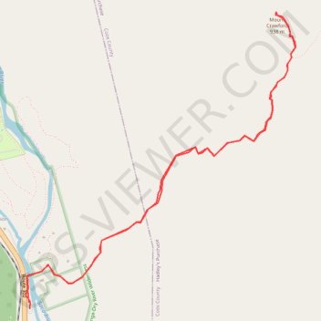
Mount Crawford
Hike from Saco River to Mount Crawford via Davis Path and Mount Crawford Spur in the Presidential Range-Dry River Wilderness. #Hiking #Mountain #River #Nature #Forest #Wilderness
- Distance: 4.6 mi
- Elevation gain: 2,064 ft
- Maximum elevation: 3,054 ft
- Elevation loss: 2,057 ft
- Minimum elevation: 988 ft
- Moving time: 2 h 12 m
- Moving speed: 2.1 mph
- Maximum speed: 3.6 mph
- Total time: 2 h 37 m
- Global speed: 1.7 mph
Interactive trail map
Make a donation
Gear up for your next adventure:
As an Amazon Associate, this site earns from qualifying purchases at no extra cost to you.
Trail profile
- Distance: 4.6 mi
- Elevation gain: 2,064 ft
- Maximum elevation: 3,054 ft
- Elevation loss: 2,057 ft
- Minimum elevation: 988 ft
- Moving time: 2 h 12 m
- Moving speed: 2.1 mph
- Maximum speed: 3.6 mph
- Total time: 2 h 37 m
- Global speed: 1.7 mph
Make a donation
Gear up for your next adventure:
As an Amazon Associate, this site earns from qualifying purchases at no extra cost to you.
About this trail
Name: Mount Crawford trail, distance, elevation, map, profile, GPS track
Coordinates: 44.11840 -71.35407 44.13682 -71.33079
Topography: Hart's Location topographic map, elevation, terrain
Make a donation
Gear up for your next adventure:
As an Amazon Associate, this site earns from qualifying purchases at no extra cost to you.
Other hiking, mountain biking, running and outdoor activity trails
Click on a trail to view its statistics, map and profile.