Make a donation
Gear up for your next adventure:
As an Amazon Associate, this site earns from qualifying purchases at no extra cost to you.
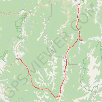
Murchison - Reefton
#Bike
- Distance: 75.9 mi
- Elevation gain: 5,991 ft
- Maximum elevation: 2,260 ft
- Elevation loss: 5,896 ft
- Minimum elevation: 554 ft
Interactive trail map
Make a donation
Gear up for your next adventure:
As an Amazon Associate, this site earns from qualifying purchases at no extra cost to you.
Trail profile
- Distance: 75.9 mi
- Elevation gain: 5,991 ft
- Maximum elevation: 2,260 ft
- Elevation loss: 5,896 ft
- Minimum elevation: 554 ft
Make a donation
Gear up for your next adventure:
As an Amazon Associate, this site earns from qualifying purchases at no extra cost to you.
About this trail
Name: Murchison - Reefton trail, distance, elevation, map, profile, GPS track
Start: Riverview Holiday Park, Riverview Road, Murchison, 7007, New Zealand (-41.79565 172.34090)
End: 14, Broadway, Reefton, Buller District, West Coast, 7830, New Zealand (-42.11981 171.86990)
Coordinates: -42.34506 171.86990 -41.79520 172.35985
Make a donation
Gear up for your next adventure:
As an Amazon Associate, this site earns from qualifying purchases at no extra cost to you.
Other hiking, mountain biking, running and outdoor activity trails
Click on a trail to view its statistics, map and profile.
Globe-Progress Gold Mine Loop MTB from Reefton via Zig Zag Track, Globe Hill Trail and Soldiers - Big River Road
New Zealand > West Coast > Buller District
Distance: 15.3 mi • Elevation gain: 3,140 ft • Maximum elevation: 2,060 ft