Duck Island
- Distance: 1.5 mi
- Elevation gain: 56 ft
- Maximum elevation: 1,302 ft
- Elevation loss: 59 ft
- Minimum elevation: 1,270 ft
- Moving time: 41 m 19 s
- Moving speed: 2.2 mph
- Maximum speed: 6.9 mph
- Total time: 59 m 19 s
- Global speed: 1.5 mph
Interactive trail map
Trail profile
- Distance: 1.5 mi
- Elevation gain: 56 ft
- Maximum elevation: 1,302 ft
- Elevation loss: 59 ft
- Minimum elevation: 1,270 ft
- Moving time: 41 m 19 s
- Moving speed: 2.2 mph
- Maximum speed: 6.9 mph
- Total time: 59 m 19 s
- Global speed: 1.5 mph
About this trail
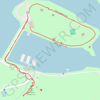
Name: Duck Island trail, distance, elevation, map, profile, GPS track
Coordinates: 36.48986 -82.48428 36.49505 -82.47799
Topography: Sullivan County topographic map, elevation, terrain
Other hiking, mountain biking, running and outdoor activity trails
Click on a trail to view its statistics, map and profile.
Comfort Suites Airport - Shady Valley Country Store
United States > Tennessee > Blount County > Alcoa > Farrport
146 mi, 2:28
Distance: 146.3 mi • Elevation gain: 10,801 ft • Maximum elevation: 3,428 ft