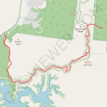
Waddlebla - Crystal Cascades
Interactive trail map
Trail profile
- Distance: 6.3 mi
- Elevation gain: 1,493 ft
- Maximum elevation: 1,762 ft
- Elevation loss: 2,165 ft
- Minimum elevation: 246 ft
- Moving time: 2 h 18 m
- Moving speed: 2.7 mph
- Maximum speed: 8.5 mph
- Total time: 2 h 28 m
- Global speed: 2.5 mph
About this trail
Name: Waddlebla - Crystal Cascades trail, distance, elevation, map, profile, GPS track
Coordinates: -16.98152 145.67796 -16.95891 145.71780
Other hiking, mountain biking, running and outdoor activity trails
Click on a trail to view its statistics, map and profile.
Crystal Cascades to Copperlode Dam Track
Australia > Queensland > Cairns
Distance: 4.2 mi • Elevation gain: 1,499 ft • Maximum elevation: 1,512 ft