Thank you for supporting this site ❤️
Make a donation
Make a donation
Gear up for your next adventure:
As an Amazon Associate, this site earns from qualifying purchases at no extra cost to you.
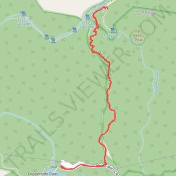
Crystal Cascades to Copperlode Dam Track
- Distance: 4.2 mi
- Elevation gain: 1,499 ft
- Maximum elevation: 1,512 ft
- Elevation loss: 1,493 ft
- Minimum elevation: 217 ft
- Moving time: 2 h 25 m
- Moving speed: 1.7 mph
- Maximum speed: 3.6 mph
- Total time: 3 h 4 m
- Global speed: 1.4 mph
Interactive trail map
Thank you for supporting this site ❤️
Make a donation
Make a donation
Gear up for your next adventure:
As an Amazon Associate, this site earns from qualifying purchases at no extra cost to you.
Trail profile
- Distance: 4.2 mi
- Elevation gain: 1,499 ft
- Maximum elevation: 1,512 ft
- Elevation loss: 1,493 ft
- Minimum elevation: 217 ft
- Moving time: 2 h 25 m
- Moving speed: 1.7 mph
- Maximum speed: 3.6 mph
- Total time: 3 h 4 m
- Global speed: 1.4 mph
Thank you for supporting this site ❤️
Make a donation
Make a donation
Gear up for your next adventure:
As an Amazon Associate, this site earns from qualifying purchases at no extra cost to you.
About this trail
Name: Crystal Cascades to Copperlode Dam Track trail, distance, elevation, map, profile, GPS track
Coordinates: -16.97997 145.67458 -16.96201 145.68090
Thank you for supporting this site ❤️
Make a donation
Make a donation
Gear up for your next adventure:
As an Amazon Associate, this site earns from qualifying purchases at no extra cost to you.
Other hiking, mountain biking, running and outdoor activity trails
Click on a trail to view its statistics, map and profile.