Make a donation
Gear up for your next adventure:
As an Amazon Associate, this site earns from qualifying purchases at no extra cost to you.
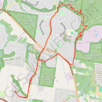
Weippin Street, Redlands and Scribbly Gum Loop
Loop hike /run via Weippin Street Conservation Area, Redlands Track Park and Scribbly Gum Conservation Area. #Hiking #Running #Loop #City #Nature #Forest #Park
- Distance: 7.5 mi
- Elevation gain: 531 ft
- Maximum elevation: 187 ft
- Elevation loss: 531 ft
- Minimum elevation: 79 ft
- Moving time: 1 h 12 m
- Moving speed: 6.2 mph
- Maximum speed: 10.8 mph
- Total time: 1 h 20 m
- Global speed: 5.6 mph
Interactive trail map
Make a donation
Gear up for your next adventure:
As an Amazon Associate, this site earns from qualifying purchases at no extra cost to you.
Trail profile
- Distance: 7.5 mi
- Elevation gain: 531 ft
- Maximum elevation: 187 ft
- Elevation loss: 531 ft
- Minimum elevation: 79 ft
- Moving time: 1 h 12 m
- Moving speed: 6.2 mph
- Maximum speed: 10.8 mph
- Total time: 1 h 20 m
- Global speed: 5.6 mph
Make a donation
Gear up for your next adventure:
As an Amazon Associate, this site earns from qualifying purchases at no extra cost to you.
About this trail
Name: Weippin Street, Redlands and Scribbly Gum Loop trail, distance, elevation, map, profile, GPS track
Start: Firtree Street, Capalaba, Greater Brisbane, Queensland, 4157, Australia (-27.56145 153.21188)
End: Firtree Street, Capalaba, Greater Brisbane, Queensland, 4157, Australia (-27.56146 153.21196)
Coordinates: -27.56362 153.21188 -27.53345 153.23785
Make a donation
Gear up for your next adventure:
As an Amazon Associate, this site earns from qualifying purchases at no extra cost to you.
Other hiking, mountain biking, running and outdoor activity trails
Click on a trail to view its statistics, map and profile.
Capalaba and Alex Hills loop
Distance: 13.2 mi • Elevation gain: 820 ft • Maximum elevation: 187 ft