Thank you for supporting this site ❤️
Make a donation
Make a donation
Gear up for your next adventure:
As an Amazon Associate, this site earns from qualifying purchases at no extra cost to you.
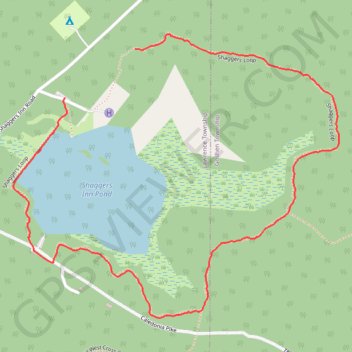
Shaggers Inn Pond Loop
- Distance: 1.7 mi
- Elevation gain: 89 ft
- Maximum elevation: 2,024 ft
- Elevation loss: 98 ft
- Minimum elevation: 1,949 ft
- Moving time: 39 m 4 s
- Moving speed: 2.7 mph
- Maximum speed: 5.3 mph
- Total time: 44 m 16 s
- Global speed: 2.4 mph
Interactive trail map
Thank you for supporting this site ❤️
Make a donation
Make a donation
Gear up for your next adventure:
As an Amazon Associate, this site earns from qualifying purchases at no extra cost to you.
Trail profile
- Distance: 1.7 mi
- Elevation gain: 89 ft
- Maximum elevation: 2,024 ft
- Elevation loss: 98 ft
- Minimum elevation: 1,949 ft
- Moving time: 39 m 4 s
- Moving speed: 2.7 mph
- Maximum speed: 5.3 mph
- Total time: 44 m 16 s
- Global speed: 2.4 mph
Thank you for supporting this site ❤️
Make a donation
Make a donation
Gear up for your next adventure:
As an Amazon Associate, this site earns from qualifying purchases at no extra cost to you.
About this trail
Name: Shaggers Inn Pond Loop trail, distance, elevation, map, profile, GPS track
Coordinates: 41.19879 -78.42201 41.20624 -78.41065
Topography: Lawrence Township topographic map, elevation, terrain
Thank you for supporting this site ❤️
Make a donation
Make a donation
Gear up for your next adventure:
As an Amazon Associate, this site earns from qualifying purchases at no extra cost to you.
Other hiking, mountain biking, running and outdoor activity trails
Click on a trail to view its statistics, map and profile.