Make a donation
Gear up for your next adventure:
As an Amazon Associate, this site earns from qualifying purchases at no extra cost to you.
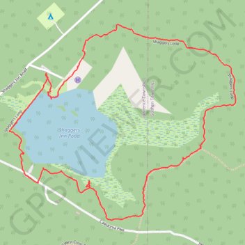
Shaggers Loop
Loop hike from Shaggers Inn Pond via Shaggers Loop and Shaggers Inn Waterfowl Dam in the Moshannon State Forest. #Hiking #Loop #Nature #Forest #Lake
- Distance: 2.2 mi
- Elevation gain: 108 ft
- Maximum elevation: 2,028 ft
- Elevation loss: 108 ft
- Minimum elevation: 1,949 ft
- Moving time: 50 m 32 s
- Moving speed: 2.6 mph
- Maximum speed: 5.7 mph
- Total time: 1 h 12 m
- Global speed: 1.8 mph
Interactive trail map
Make a donation
Gear up for your next adventure:
As an Amazon Associate, this site earns from qualifying purchases at no extra cost to you.
Trail profile
- Distance: 2.2 mi
- Elevation gain: 108 ft
- Maximum elevation: 2,028 ft
- Elevation loss: 108 ft
- Minimum elevation: 1,949 ft
- Moving time: 50 m 32 s
- Moving speed: 2.6 mph
- Maximum speed: 5.7 mph
- Total time: 1 h 12 m
- Global speed: 1.8 mph
Make a donation
Gear up for your next adventure:
As an Amazon Associate, this site earns from qualifying purchases at no extra cost to you.
About this trail
Name: Shaggers Loop trail, distance, elevation, map, profile, GPS track
Coordinates: 41.19884 -78.42212 41.20628 -78.41067
Topography: Lawrence Township topographic map, elevation, terrain
Make a donation
Gear up for your next adventure:
As an Amazon Associate, this site earns from qualifying purchases at no extra cost to you.
Other hiking, mountain biking, running and outdoor activity trails
Click on a trail to view its statistics, map and profile.
Shaggers Inn Pond Loop
United States > Pennsylvania > Clearfield County > Lawrence Township
Distance: 1.7 mi • Elevation gain: 89 ft • Maximum elevation: 2,024 ft