Quartz Hill, Garfield WW and Goldfields Track walk
- Distance: 4.9 mi
- Elevation gain: 482 ft
- Maximum elevation: 1,289 ft
- Elevation loss: 486 ft
- Minimum elevation: 974 ft
- Moving time: 1 h 43 m
- Moving speed: 2.9 mph
- Maximum speed: 21.0 mph
- Total time: 1 h 56 m
- Global speed: 2.5 mph
Interactive trail map
Trail profile
- Distance: 4.9 mi
- Elevation gain: 482 ft
- Maximum elevation: 1,289 ft
- Elevation loss: 486 ft
- Minimum elevation: 974 ft
- Moving time: 1 h 43 m
- Moving speed: 2.9 mph
- Maximum speed: 21.0 mph
- Total time: 1 h 56 m
- Global speed: 2.5 mph
About this trail
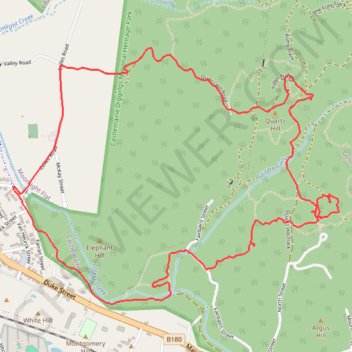
Name: Quartz Hill, Garfield WW and Goldfields Track walk trail, distance, elevation, map, profile, GPS track
Coordinates: -37.07641 144.23880 -37.06271 144.26055
Other hiking, mountain biking, running and outdoor activity trails
Click on a trail to view its statistics, map and profile.
Garfield Water Wheel, Garfield mine, Quartz Hill and Goldfields track walk
Distance: 6.1 mi • Elevation gain: 856 ft • Maximum elevation: 1,355 ft
Quartz Hill, Quartz Hill mine, sailors Gully and Goldfields Track
Australia > Victoria > Castlemaine
Distance: 4.5 mi • Elevation gain: 433 ft • Maximum elevation: 1,289 ft
Specimen Gully, Pineys, Golden Point Res, Garfield Water Wheel, Chewton, Castlemaine, Botanic gardens walk
Distance: 11.4 mi • Elevation gain: 883 ft • Maximum elevation: 1,535 ft