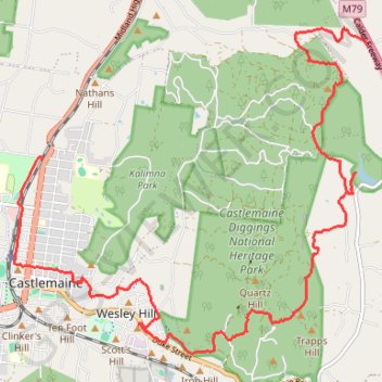
Specimen Gully, Pineys, Golden Point Res, Garfield Water Wheel, Chewton, Castlemaine, Botanic gardens walk
- Distance: 11.4 mi
- Elevation gain: 883 ft
- Maximum elevation: 1,535 ft
- Elevation loss: 1,355 ft
- Minimum elevation: 925 ft
- Moving time: 3 h 33 m
- Moving speed: 3.2 mph
- Maximum speed: 6.9 mph
- Total time: 5 h 9 m
- Global speed: 2.2 mph
Interactive trail map
Trail profile
- Distance: 11.4 mi
- Elevation gain: 883 ft
- Maximum elevation: 1,535 ft
- Elevation loss: 1,355 ft
- Minimum elevation: 925 ft
- Moving time: 3 h 33 m
- Moving speed: 3.2 mph
- Maximum speed: 6.9 mph
- Total time: 5 h 9 m
- Global speed: 2.2 mph
About this trail
Name: Specimen Gully, Pineys, Golden Point Res, Garfield Water Wheel, Chewton, Castlemaine, Botanic gardens walk trail, distance, elevation, map, profile, GPS track
End: Downes Road, Castlemaine, Shire of Mount Alexander, Victoria, 3450, Australia (-37.04939 144.21933)
Coordinates: -37.07638 144.21452 -37.03138 144.27582
Other hiking, mountain biking, running and outdoor activity trails
Click on a trail to view its statistics, map and profile.
Garfield Water Wheel, Garfield mine, Quartz Hill and Goldfields track walk
Distance: 6.1 mi • Elevation gain: 856 ft • Maximum elevation: 1,355 ft
Goldfields Track - Castlemaine circuit
Australia > Victoria > Castlemaine
#MTB #Loop #Goldfields #Castlemaine
Distance: 10.5 mi • Elevation gain: 584 ft • Maximum elevation: 1,253 ft
Quartz Hill, Garfield WW and Goldfields Track walk
Australia > Victoria > Castlemaine
Distance: 4.9 mi • Elevation gain: 482 ft • Maximum elevation: 1,289 ft
Quartz Hill, Quartz Hill mine, sailors Gully and Goldfields Track
Australia > Victoria > Castlemaine
Distance: 4.5 mi • Elevation gain: 433 ft • Maximum elevation: 1,289 ft
Castlemaine Diggins Park and Kalimns Park Loop
Loop hike via Pikestreet Road, The Folly Track, Welsh Street, Forest Creek Track, Expedition Pass Reservoir, Nicholson Extension Track, No 1 Remote Track, Haws No 1 Track, North West Break and Unknown Miners Grave in the Castlemaine Diggins National Heritage Park and the Kalimns Park. #Hiking #Loop #Nature…
Distance: 7.3 mi • Elevation gain: 840 ft • Maximum elevation: 1,421 ft