Three Sisters Falls
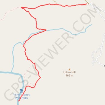
Interactive trail map
Trail profile
- Distance: 2.0 mi
- Elevation gain: 154 ft
- Maximum elevation: 2,927 ft
- Elevation loss: 961 ft
- Minimum elevation: 2,080 ft
About this trail
Name: Three Sisters Falls trail, distance, elevation, map, profile, GPS track
Coordinates: 32.97162 -116.68846 32.98462 -116.67752
Topography: San Diego County topographic map, elevation, terrain
Other hiking, mountain biking, running and outdoor activity trails
Click on a trail to view its statistics, map and profile.
Three Sisters Falls Trail in Cleveland National Forest
United States > California > San Diego County
The Three Sisters Falls Trail in Cleveland National Forest offers hikers a challenging yet rewarding journey through diverse landscapes. The path descends into a rugged canyon, providing expansive views of the surrounding mountains and the Boulder Creek valley. Upon reaching the falls, hikers are greeted by…
Distance: 3.9 mi • Elevation gain: 968 ft • Maximum elevation: 2,917 ft