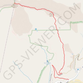
Mount San Antonio and Mount Harwood
Hike to Mount San Antonio and Mount Harwood by the Register Ridge and the Devils Backbone Trail in the San Gabriel Mountains National Monument and the Angeles National Forest. #Hiking #Mountain #Nature #Forest #Angeles
- Distance: 3.5 mi
- Elevation gain: 4,114 ft
- Maximum elevation: 10,066 ft
- Elevation loss: 246 ft
- Minimum elevation: 6,194 ft
Interactive trail map
Trail profile
- Distance: 3.5 mi
- Elevation gain: 4,114 ft
- Maximum elevation: 10,066 ft
- Elevation loss: 246 ft
- Minimum elevation: 6,194 ft
About this trail
Name: Mount San Antonio and Mount Harwood trail, distance, elevation, map, profile, GPS track
Start: 3, Falls Road, San Bernardino County, California, 91759, United States (34.26624 -117.62688)
End: Devils Backbone Trail, Los Angeles County, California, 91759, United States (34.28912 -117.64640)
Coordinates: 34.26624 -117.64640 34.28912 -117.62688
Topography: San Bernardino County topographic map, elevation, terrain
Other hiking, mountain biking, running and outdoor activity trails
Click on a trail to view its statistics, map and profile.
Three T's Trail
United States > California > San Bernardino County
Loop hike to Timber Mountain, Telegraph Peak and Thunder Mountain along the Three T's Trail via Icehouse Canyon Trail, Icehouse Saddle, Mount Baldy Notch and ount Baldy Road in Angeles National Forest. #Hiking #Loop #Mountain #Nature #Forest #Angeles
Distance: 15.1 mi • Elevation gain: 5,476 ft • Maximum elevation: 8,944 ft