Hanging Lake Trail in White River National Forest
The Hanging Lake Trail offers an unforgettable hiking experience in Colorado's White River National Forest. The route follows a scenic canyon, with lush greenery and multiple footbridges crossing over Dead Horse Creek, leading to the striking turquoise lake. As you reach the top, you're rewarded with a breathtaking view of the hanging lake surrounded by dramatic limestone cliffs, and a nearby waterfall cascading from Sprouting Rock. While the trail is moderately challenging due to its steep ascent, the stunning natural beauty at the summit is well worth the effort. #Hiking #Canyon #Lake #Waterfall #River #Forest #Nature
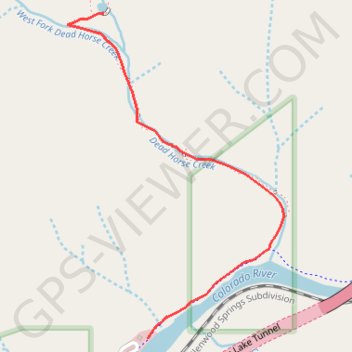
- Distance: 1.4 mi
- Elevation gain: 1,086 ft
- Maximum elevation: 7,215 ft
- Elevation loss: 26 ft
- Minimum elevation: 6,125 ft
Interactive trail map
Trail profile
- Distance: 1.4 mi
- Elevation gain: 1,086 ft
- Maximum elevation: 7,215 ft
- Elevation loss: 26 ft
- Minimum elevation: 6,125 ft
About this trail
Name: Hanging Lake Trail in White River National Forest trail, distance, elevation, map, profile, GPS track
End: Hanging Lake Trail, Garfield County, Colorado, United States (39.60118 -107.19170)
Coordinates: 39.58960 -107.19336 39.60118 -107.18338
Topography: Garfield County topographic map, elevation, terrain
Other hiking, mountain biking, running and outdoor activity trails
Click on a trail to view its statistics, map and profile.
Hanging Lake
United States > Colorado > Garfield County
Starting beside the Colorado River in Glenwood Canyon, the route leaves the canyon floor and enters Dead Horse Creek Canyon, climbing into the White River National Forest. The ascent follows a shaded, rocky gorge with footbridges, creek crossings, switchbacks, rock steps, and fire-marked canyon scenery before…
Distance: 3.1 mi • Elevation gain: 1,240 ft • Maximum elevation: 7,297 ft