Chutes Jacks ride
Afternoon Mountain Bike Ride
- Distance: 6.1 mi
- Elevation gain: 1,572 ft
- Maximum elevation: 7,438 ft
- Elevation loss: 1,565 ft
- Minimum elevation: 6,568 ft
- Moving time: 48 m 24 s
- Moving speed: 7.6 mph
- Maximum speed: 21.6 mph
- Total time: 53 m 29 s
- Global speed: 6.8 mph
Interactive trail map
Trail profile
- Distance: 6.1 mi
- Elevation gain: 1,572 ft
- Maximum elevation: 7,438 ft
- Elevation loss: 1,565 ft
- Minimum elevation: 6,568 ft
- Moving time: 48 m 24 s
- Moving speed: 7.6 mph
- Maximum speed: 21.6 mph
- Total time: 53 m 29 s
- Global speed: 6.8 mph
About this trail
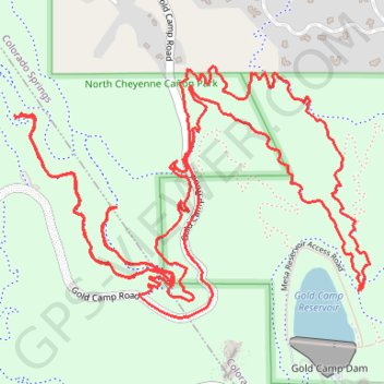
Name: Chutes Jacks ride trail, distance, elevation, map, profile, GPS track
Start: Ladders, Colorado Springs, El Paso County, Colorado, 80905, United States (38.80012 -104.87662)
End: Upper Chutes, Colorado Springs, El Paso County, Colorado, 80905, United States (38.80012 -104.87668)
Coordinates: 38.79462 -104.88413 38.80310 -104.86880
Topography: Colorado Springs topographic map, elevation, terrain
Other hiking, mountain biking, running and outdoor activity trails
Click on a trail to view its statistics, map and profile.
Ladder Extension trail
United States > Colorado > El Paso County > Colorado Springs
North Cheyenne Canyon Park
Distance: 6.0 mi • Elevation gain: 1,578 ft • Maximum elevation: 7,392 ft