Ladder Extension trail
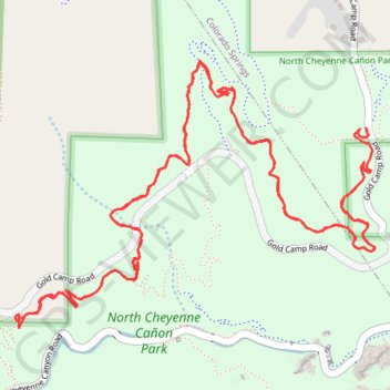
North Cheyenne Canyon Park
- Distance: 6.0 mi
- Elevation gain: 1,578 ft
- Maximum elevation: 7,392 ft
- Elevation loss: 1,532 ft
- Minimum elevation: 7,037 ft
- Moving time: 54 m
- Moving speed: 6.7 mph
- Maximum speed: 23.4 mph
- Total time: 1 h 9 m
- Global speed: 5.2 mph
Interactive trail map
Trail profile
- Distance: 6.0 mi
- Elevation gain: 1,578 ft
- Maximum elevation: 7,392 ft
- Elevation loss: 1,532 ft
- Minimum elevation: 7,037 ft
- Moving time: 54 m
- Moving speed: 6.7 mph
- Maximum speed: 23.4 mph
- Total time: 1 h 9 m
- Global speed: 5.2 mph
About this trail
Name: Ladder Extension trail trail, distance, elevation, map, profile, GPS track
Start: Ladders, Colorado Springs, El Paso County, Colorado, 80905, United States (38.79996 -104.87684)
End: Ladders, Colorado Springs, El Paso County, Colorado, 80905, United States (38.79826 -104.87659)
Coordinates: 38.79228 -104.89403 38.80248 -104.87636
Topography: Colorado Springs topographic map, elevation, terrain
Other hiking, mountain biking, running and outdoor activity trails
Click on a trail to view its statistics, map and profile.
Chutes Jacks ride
United States > Colorado > El Paso County > Colorado Springs
Afternoon Mountain Bike Ride
Distance: 6.1 mi • Elevation gain: 1,572 ft • Maximum elevation: 7,438 ft
Walked the North Cheyenne Canyon trail
United States > Colorado > El Paso County
Distance: 0.5 mi • Elevation gain: 115 ft • Maximum elevation: 6,850 ft