Hartoft End Loop
Ryedale Mountain Biking
- Distance: 12.1 mi
- Elevation gain: 1,381 ft
- Maximum elevation: 1,083 ft
- Elevation loss: 1,385 ft
- Minimum elevation: 335 ft
- Moving time: 1 h 45 m
- Moving speed: 6.9 mph
- Maximum speed: 23.4 mph
- Total time: 2 h 25 m
- Global speed: 5.0 mph
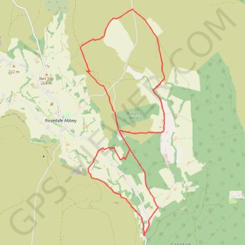
Interactive trail map
Trail profile
- Distance: 12.1 mi
- Elevation gain: 1,381 ft
- Maximum elevation: 1,083 ft
- Elevation loss: 1,385 ft
- Minimum elevation: 335 ft
- Moving time: 1 h 45 m
- Moving speed: 6.9 mph
- Maximum speed: 23.4 mph
- Total time: 2 h 25 m
- Global speed: 5.0 mph
About this trail
Name: Hartoft End Loop trail, distance, elevation, map, profile, GPS track
Coordinates: 54.32385 -0.87888 54.38297 -0.84109
Other hiking, mountain biking, running and outdoor activity trails
Click on a trail to view its statistics, map and profile.
Hartoft End Loop
United Kingdom > England > North Yorkshire > Rosedale Abbey
Distance: 12.9 mi • Elevation gain: 1,637 ft • Maximum elevation: 1,220 ft
Sinnington MTB loop
United Kingdom > England > North Yorkshire > Sinnington
Distance: 14.2 mi • Elevation gain: 1,522 ft • Maximum elevation: 906 ft
Hartoft Rigg
United Kingdom > England > North Yorkshire > Rosedale Abbey
Distance: 5.8 mi • Elevation gain: 837 ft • Maximum elevation: 942 ft
Farndale
United Kingdom > England > North Yorkshire > Appleton-le-Moors
Ryedale Mountain Biking
Distance: 32.9 mi • Elevation gain: 4,104 ft • Maximum elevation: 1,335 ft