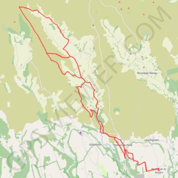
Farndale
Ryedale Mountain Biking
- Distance: 32.9 mi
- Elevation gain: 4,104 ft
- Maximum elevation: 1,335 ft
- Elevation loss: 4,104 ft
- Minimum elevation: 262 ft
- Moving time: 4 h 49 m
- Moving speed: 6.8 mph
- Maximum speed: 33.3 mph
- Total time: 6 h 4 m
- Global speed: 5.4 mph
Interactive trail map
Trail profile
- Distance: 32.9 mi
- Elevation gain: 4,104 ft
- Maximum elevation: 1,335 ft
- Elevation loss: 4,104 ft
- Minimum elevation: 262 ft
- Moving time: 4 h 49 m
- Moving speed: 6.8 mph
- Maximum speed: 33.3 mph
- Total time: 6 h 4 m
- Global speed: 5.4 mph
About this trail
Name: Farndale trail, distance, elevation, map, profile, GPS track
Coordinates: 54.28088 -1.05059 54.40296 -0.87222
Other hiking, mountain biking, running and outdoor activity trails
Click on a trail to view its statistics, map and profile.
Hartoft End Loop
United Kingdom > England > North Yorkshire > Rosedale Abbey
Distance: 12.9 mi • Elevation gain: 1,637 ft • Maximum elevation: 1,220 ft
Rosedale Abbey north loop to Fryup Dale
United Kingdom > England > North Yorkshire > Rosedale Abbey
Distance: 19.8 mi • Elevation gain: 2,300 ft • Maximum elevation: 1,385 ft
Church Houses Loop Mountain Biking
United Kingdom > England > North Yorkshire > Church Houses
Distance: 14.3 mi • Elevation gain: 2,116 ft • Maximum elevation: 1,289 ft
Hartoft End Loop
United Kingdom > England > North Yorkshire
Ryedale Mountain Biking
Distance: 12.1 mi • Elevation gain: 1,381 ft • Maximum elevation: 1,083 ft
Gillamoor loop walk
United Kingdom > England > North Yorkshire > Gillamoor
Distance: 5.5 mi • Elevation gain: 607 ft • Maximum elevation: 696 ft
Helmsley Africa Loop
United Kingdom > England > North Yorkshire > Helmsley
Distance: 16.6 mi • Elevation gain: 1,942 ft • Maximum elevation: 1,027 ft
Lastingham MTB Loop
United Kingdom > England > North Yorkshire > Lastingham
Distance: 27.5 mi • Elevation gain: 3,432 ft • Maximum elevation: 1,214 ft
Sinnington MTB loop
United Kingdom > England > North Yorkshire > Sinnington
Distance: 14.2 mi • Elevation gain: 1,522 ft • Maximum elevation: 906 ft
Gillamoor MTB Loop
United Kingdom > England > North Yorkshire > Gillamoor
Distance: 8.8 mi • Elevation gain: 1,227 ft • Maximum elevation: 1,030 ft
St Gregory's loop
United Kingdom > England > North Yorkshire > Helmsley
Distance: 19.0 mi • Elevation gain: 1,722 ft • Maximum elevation: 965 ft
Westerdale top
United Kingdom > England > North Yorkshire > Westerdale
Mountain Biking
Distance: 17.0 mi • Elevation gain: 2,175 ft • Maximum elevation: 1,385 ft
Hartoft Rigg
United Kingdom > England > North Yorkshire > Rosedale Abbey
Distance: 5.8 mi • Elevation gain: 837 ft • Maximum elevation: 942 ft