Make a donation
Gear up for your next adventure:
As an Amazon Associate, this site earns from qualifying purchases at no extra cost to you.
Rydal Adventure Lab
- Distance: 1.7 mi
- Elevation gain: 230 ft
- Maximum elevation: 308 ft
- Elevation loss: 200 ft
- Minimum elevation: 190 ft
- Moving time: 32 m 58 s
- Moving speed: 3.0 mph
- Maximum speed: 27.9 mph
- Total time: 46 m 24 s
- Global speed: 2.1 mph
Interactive trail map
Make a donation
Gear up for your next adventure:
As an Amazon Associate, this site earns from qualifying purchases at no extra cost to you.
Trail profile
- Distance: 1.7 mi
- Elevation gain: 230 ft
- Maximum elevation: 308 ft
- Elevation loss: 200 ft
- Minimum elevation: 190 ft
- Moving time: 32 m 58 s
- Moving speed: 3.0 mph
- Maximum speed: 27.9 mph
- Total time: 46 m 24 s
- Global speed: 2.1 mph
Make a donation
Gear up for your next adventure:
As an Amazon Associate, this site earns from qualifying purchases at no extra cost to you.
About this trail
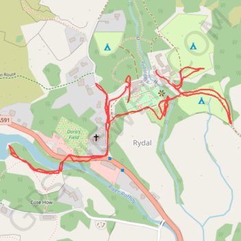
Name: Rydal Adventure Lab trail, distance, elevation, map, profile, GPS track
Coordinates: 54.44643 -2.98557 54.44915 -2.97577
Make a donation
Gear up for your next adventure:
As an Amazon Associate, this site earns from qualifying purchases at no extra cost to you.
Other hiking, mountain biking, running and outdoor activity trails
Click on a trail to view its statistics, map and profile.
Rydal Cave, Grasmere and Rydal Water Loop
United Kingdom > England > Westmorland and Furness > Rydal
Distance: 7.0 mi • Elevation gain: 1,007 ft • Maximum elevation: 459 ft
Loughrigg Fell loop from Ambleside
United Kingdom > England > Westmorland and Furness > Ambleside
Distance: 7.9 mi • Elevation gain: 1,604 ft • Maximum elevation: 1,079 ft
Fairfield Horseshoe Loop
United Kingdom > England > Westmorland and Furness > Ambleside
Distance: 9.9 mi • Elevation gain: 3,054 ft • Maximum elevation: 2,854 ft
Rydal Water and Grasmere
United Kingdom > England > Westmorland and Furness > Ambleside
Distance: 9.9 mi • Elevation gain: 1,106 ft • Maximum elevation: 459 ft
Make a donation
Gear up for your next adventure:
As an Amazon Associate, this site earns from qualifying purchases at no extra cost to you.
Ambleside to Rydal Loop
United Kingdom > England > Westmorland and Furness > Ambleside
Distance: 5.4 mi • Elevation gain: 827 ft • Maximum elevation: 650 ft
Rydal Sculpture trail
United Kingdom > England > Westmorland and Furness > Rydal
Distance: 0.9 mi • Elevation gain: 135 ft • Maximum elevation: 377 ft