Loughrigg Fell loop from Ambleside
- Distance: 7.9 mi
- Elevation gain: 1,604 ft
- Maximum elevation: 1,079 ft
- Elevation loss: 1,581 ft
- Minimum elevation: 157 ft
- Moving time: 3 h 40 m
- Moving speed: 2.1 mph
- Maximum speed: 7.6 mph
- Total time: 5 h 11 m
- Global speed: 1.5 mph
Interactive trail map
Trail profile
- Distance: 7.9 mi
- Elevation gain: 1,604 ft
- Maximum elevation: 1,079 ft
- Elevation loss: 1,581 ft
- Minimum elevation: 157 ft
- Moving time: 3 h 40 m
- Moving speed: 2.1 mph
- Maximum speed: 7.6 mph
- Total time: 5 h 11 m
- Global speed: 1.5 mph
About this trail
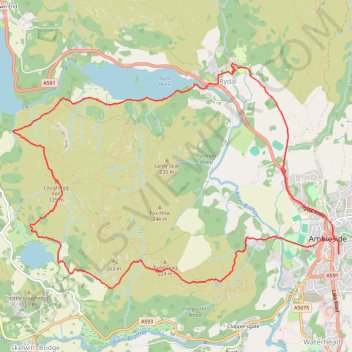
Name: Loughrigg Fell loop from Ambleside trail, distance, elevation, map, profile, GPS track
Coordinates: 54.42710 -3.01548 54.44886 -2.96120
Other hiking, mountain biking, running and outdoor activity trails
Click on a trail to view its statistics, map and profile.
Rydal Cave, Grasmere and Rydal Water Loop
United Kingdom > England > Westmorland and Furness > Rydal
Distance: 7.0 mi • Elevation gain: 1,007 ft • Maximum elevation: 459 ft
Fairfield Horseshoe Loop
United Kingdom > England > Westmorland and Furness > Ambleside
Distance: 9.9 mi • Elevation gain: 3,054 ft • Maximum elevation: 2,854 ft
Rydal Water and Grasmere
United Kingdom > England > Westmorland and Furness > Ambleside
Distance: 9.9 mi • Elevation gain: 1,106 ft • Maximum elevation: 459 ft
Ambleside to Rydal Loop
United Kingdom > England > Westmorland and Furness > Ambleside
Distance: 5.4 mi • Elevation gain: 827 ft • Maximum elevation: 650 ft
Rydal Adventure Lab
United Kingdom > England > Westmorland and Furness > Rydal
Distance: 1.7 mi • Elevation gain: 230 ft • Maximum elevation: 308 ft
Rydal Sculpture trail
United Kingdom > England > Westmorland and Furness > Rydal
Distance: 0.9 mi • Elevation gain: 135 ft • Maximum elevation: 377 ft