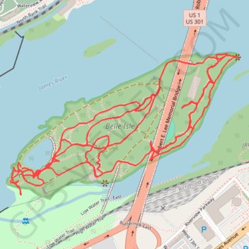
Trace of Belle Isle trail system
- Distance: 4.0 mi
- Elevation gain: 358 ft
- Maximum elevation: 102 ft
- Elevation loss: 354 ft
- Minimum elevation: 10 ft
- Moving time: 2 h 31 m
- Moving speed: 1.6 mph
- Maximum speed: 3.1 mph
- Total time: 2 h 46 m
- Global speed: 1.4 mph
Interactive trail map
Trail profile
- Distance: 4.0 mi
- Elevation gain: 358 ft
- Maximum elevation: 102 ft
- Elevation loss: 354 ft
- Minimum elevation: 10 ft
- Moving time: 2 h 31 m
- Moving speed: 1.6 mph
- Maximum speed: 3.1 mph
- Total time: 2 h 46 m
- Global speed: 1.4 mph
About this trail
Name: Trace of Belle Isle trail system trail, distance, elevation, map, profile, GPS track
Coordinates: 37.52685 -77.45756 37.53165 -77.44772
Topography: Richmond topographic map, elevation, terrain
Other hiking, mountain biking, running and outdoor activity trails
Click on a trail to view its statistics, map and profile.
A bike ride in part to survey the new North Bank Trail section next to Hollywood
United States > Virginia > Richmond
Distance: 8.7 mi • Elevation gain: 591 ft • Maximum elevation: 243 ft