Make a donation
Gear up for your next adventure:
As an Amazon Associate, this site earns from qualifying purchases at no extra cost to you.
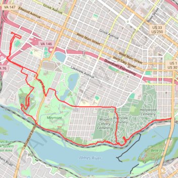
A bike ride in part to survey the new North Bank Trail section next to Hollywood
- Distance: 8.7 mi
- Elevation gain: 591 ft
- Maximum elevation: 243 ft
- Elevation loss: 591 ft
- Minimum elevation: 82 ft
Interactive trail map
Make a donation
Gear up for your next adventure:
As an Amazon Associate, this site earns from qualifying purchases at no extra cost to you.
Trail profile
- Distance: 8.7 mi
- Elevation gain: 591 ft
- Maximum elevation: 243 ft
- Elevation loss: 591 ft
- Minimum elevation: 82 ft
Make a donation
Gear up for your next adventure:
As an Amazon Associate, this site earns from qualifying purchases at no extra cost to you.
About this trail
Name: A bike ride in part to survey the new North Bank Trail section next to Hollywood trail, distance, elevation, map, profile, GPS track
Start: 3411, Rosewood Avenue, Stadium, Richmond, Virginia, 23221, United States (37.55180 -77.48799)
End: 3412, Maplewood Avenue, Stadium, Richmond, Virginia, 23221, United States (37.55154 -77.48818)
Coordinates: 37.53002 -77.48933 37.55180 -77.44957
Topography: Richmond topographic map, elevation, terrain
Make a donation
Gear up for your next adventure:
As an Amazon Associate, this site earns from qualifying purchases at no extra cost to you.
Other hiking, mountain biking, running and outdoor activity trails
Click on a trail to view its statistics, map and profile.
Byrd Park
United States > Virginia > Richmond
Distance: 1.6 mi • Elevation gain: 108 ft • Maximum elevation: 236 ft
Trace of Belle Isle trail system
United States > Virginia > Richmond
Distance: 4.0 mi • Elevation gain: 358 ft • Maximum elevation: 102 ft
Maymount Park Japanese Garden Loop
United States > Virginia > Richmond
Distance: 0.9 mi • Elevation gain: 125 ft • Maximum elevation: 197 ft