Make a donation
Gear up for your next adventure:
As an Amazon Associate, this site earns from qualifying purchases at no extra cost to you.
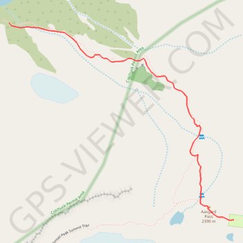
#2c Aasgard Pass, 1m, 2250ft
- Distance: 1.1 mi
- Elevation gain: 2,221 ft
- Maximum elevation: 7,815 ft
- Elevation loss: 7 ft
- Minimum elevation: 5,594 ft
Interactive trail map
Make a donation
Gear up for your next adventure:
As an Amazon Associate, this site earns from qualifying purchases at no extra cost to you.
Trail profile
- Distance: 1.1 mi
- Elevation gain: 2,221 ft
- Maximum elevation: 7,815 ft
- Elevation loss: 7 ft
- Minimum elevation: 5,594 ft
Make a donation
Gear up for your next adventure:
As an Amazon Associate, this site earns from qualifying purchases at no extra cost to you.
About this trail
Name: #2c Aasgard Pass, 1m, 2250ft trail, distance, elevation, map, profile, GPS track
Start: Aasgard Pass Trail, Chelan County, Washington, United States (47.48751 -120.83322)
Coordinates: 47.48030 -120.83322 47.48751 -120.82110
Topography: Chelan County topographic map, elevation, terrain
Make a donation
Gear up for your next adventure:
As an Amazon Associate, this site earns from qualifying purchases at no extra cost to you.
Other hiking, mountain biking, running and outdoor activity trails
Click on a trail to view its statistics, map and profile.
The Enchantments
United States > Washington > Chelan County
From the Stuart Lake Trail, the route enters the Alpine Lakes Wilderness through forest, creek crossings, and gradually rougher alpine terrain before reaching Colchuck Lake, a striking first landmark set below Colchuck Peak and Dragontail Peak, with Aasgard Pass rising steeply above the far shore as the…
Distance: 18.2 mi • Elevation gain: 4,928 ft • Maximum elevation: 7,818 ft
Northern part of the Pacific Crest Trail (PCT)
United States > Oregon > Klamath County
Hike on the Pacific Crest National Scenic Trail from Crater Lake to Canada Border through Oregon and Washington along the Sierra Nevada and Cascade mountain ranges. #Hiking #Mountain #SierraNevada #Cascade #Nature #Forest #Park #PCT
Distance: 744.6 mi • Elevation gain: 145,367 ft • Maximum elevation: 7,569 ft
Enchantmentpeak on GPSies.com
United States > Washington > Chelan County
Distance: 7.6 mi • Elevation gain: 5,830 ft • Maximum elevation: 8,438 ft
Enchantments traverse
United States > Washington > Chelan County
Distance: 20.3 mi • Elevation gain: 5,115 ft • Maximum elevation: 7,818 ft
Make a donation
Gear up for your next adventure:
As an Amazon Associate, this site earns from qualifying purchases at no extra cost to you.