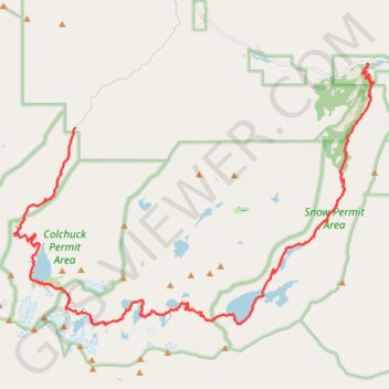
The Enchantments
From the Stuart Lake Trail, the route enters the Alpine Lakes Wilderness through forest, creek crossings, and gradually rougher alpine terrain before reaching Colchuck Lake, a striking first landmark set below Colchuck Peak and Dragontail Peak, with Aasgard Pass rising steeply above the far shore as the natural gateway into the Enchantments.
After Aasgard Pass, the trail opens into a high granite basin where the lakes become the main thread of the journey: Isolation Lake appears first in the upper basin, followed by the clearer, more intricate chain of Inspiration Lake, Perfection Lake, Leprechaun Lake, and Lake Viviane, all surrounded by polished slabs, larch groves, streams, waterfalls, and landmark summits such as Little Annapurna, McClellan Peak, and Prusik Peak.
The route then leaves the Core Enchantments on the Snow Lakes side, descending past the broad waters of Snow Lakes and onward to Nada Lake, where the scenery gradually shifts from open alpine rock and cascades to a long forested valley leading toward the Snow Lakes Trailhead, one of the main access points to this protected and permit-managed wilderness area.
#Hiking #Mountain #Lake #River #Waterfall #Forest #Nature
- Distance: 18.2 mi
- Elevation gain: 4,928 ft
- Maximum elevation: 7,818 ft
- Elevation loss: 6,969 ft
- Minimum elevation: 1,325 ft
Interactive trail map
Trail profile
- Distance: 18.2 mi
- Elevation gain: 4,928 ft
- Maximum elevation: 7,818 ft
- Elevation loss: 6,969 ft
- Minimum elevation: 1,325 ft
About this trail
Name: The Enchantments trail, distance, elevation, map, profile, GPS track
Start: Stuart Lake Trail, Chelan County, Washington, United States (47.52775 -120.82094)
Coordinates: 47.47695 -120.84400 47.54416 -120.70688
Topography: Chelan County topographic map, elevation, terrain
Other hiking, mountain biking, running and outdoor activity trails
Click on a trail to view its statistics, map and profile.
Cashmere Mountain via Little Eightmile Lake, Eightmile-Trout Creek Trail, Lake Caroline and Windy Pass
United States > Washington > Chelan County
The hike to Cashmere Mountain is a spectacular journey through the heart of the Alpine Lakes Wilderness, offering a diverse range of views. Starting at the Eightmile Lake Trailhead, the route leads you past scenic lakes like Little Eightmile Lake and Lake Caroline, each with pristine alpine waters framed by…
Distance: 9.5 mi • Elevation gain: 5,502 ft • Maximum elevation: 8,235 ft
Colchuck Lake via Stuart Lake Trail and Colchuck Lake Trail in Alpine Lakes Wilderness
United States > Washington > Chelan County
The Colchuck Lake hike offers a challenging yet incredibly rewarding adventure through Washington's rugged Alpine Lakes Wilderness. As you ascend, the trail meanders through dense forests and rocky terrain, with spectacular views opening up toward Dragontail Peak and the Colchuck Glacier. The final…
Distance: 8.0 mi • Elevation gain: 2,326 ft • Maximum elevation: 5,587 ft
Lake Stuart via Stuart Lake Trail in Alpine Lakes Wilderness
United States > Washington > Chelan County
The hike to Lake Stuart in the Alpine Lakes Wilderness offers a serene journey through lush forests, alongside Mountaineer Creek, and past impressive glacial boulders. The route gradually transitions from shaded woodland paths to expansive meadows that unveil stunning views of Mount Stuart towering above the…
Distance: 4.1 mi • Elevation gain: 1,765 ft • Maximum elevation: 5,118 ft
Colchuck Lake Trail in Okanogan-Wenatchee National Forest
United States > Washington > Chelan County
The Colchuck Lake Trail is a delightful hike that leads you to one of the most stunning alpine lakes in Washington. Starting off with a gentle climb through lush forests, the trail gradually transforms into rocky terrain, offering breathtaking views of the towering Dragontail and Colchuck Peaks as you near the…
Distance: 9.6 mi • Elevation gain: 2,375 ft • Maximum elevation: 5,636 ft
Northern part of the Pacific Crest Trail (PCT)
United States > Oregon > Klamath County
Hike on the Pacific Crest National Scenic Trail from Crater Lake to Canada Border through Oregon and Washington along the Sierra Nevada and Cascade mountain ranges. #Hiking #Mountain #SierraNevada #Cascade #Nature #Forest #Park #PCT
Distance: 744.6 mi • Elevation gain: 145,367 ft • Maximum elevation: 7,569 ft
Enchantments traverse
United States > Washington > Chelan County
Distance: 20.3 mi • Elevation gain: 5,115 ft • Maximum elevation: 7,818 ft
Enchantmentpeak on GPSies.com
United States > Washington > Chelan County
Distance: 7.6 mi • Elevation gain: 5,830 ft • Maximum elevation: 8,438 ft
#2c Aasgard Pass, 1m, 2250ft
United States > Washington > Chelan County
Distance: 1.1 mi • Elevation gain: 2,221 ft • Maximum elevation: 7,815 ft