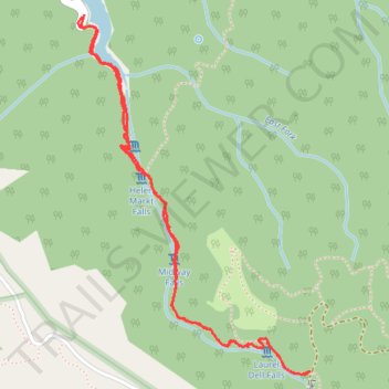
Cataract Falls Trail from Alpine Lake in Mount Tamalpais Watershed
The Cataract Trail in Mount Tamalpais Watershed offers hikers a serene journey through dense forests, accompanied by the soothing sounds of cascading waterfalls. Along the path, one can observe a series of waterfalls, including Cataract Falls, Helen Markt Falls, Midway Falls, and Laurel Dell Falls, each presenting a unique natural spectacle. The trail's combination of well-maintained paths and natural beauty makes it a rewarding experience for those seeking a moderate hike in a tranquil setting. #Hiking #Waterfall #Forest #Nature #Lake #River
- Distance: 3.1 mi
- Elevation gain: 1,214 ft
- Maximum elevation: 1,762 ft
- Elevation loss: 1,227 ft
- Minimum elevation: 696 ft
- Moving time: 1 h 24 m
- Moving speed: 2.2 mph
- Maximum speed: 4.6 mph
- Total time: 1 h 31 m
- Global speed: 2.0 mph
Interactive trail map
Trail profile
- Distance: 3.1 mi
- Elevation gain: 1,214 ft
- Maximum elevation: 1,762 ft
- Elevation loss: 1,227 ft
- Minimum elevation: 696 ft
- Moving time: 1 h 24 m
- Moving speed: 2.2 mph
- Maximum speed: 4.6 mph
- Total time: 1 h 31 m
- Global speed: 2.0 mph
About this trail
Name: Cataract Falls Trail from Alpine Lake in Mount Tamalpais Watershed trail, distance, elevation, map, profile, GPS track
Start: Fairfax-Bolinas Road, Marin County, California, 94970, United States (37.93696 -122.63801)
End: Fairfax-Bolinas Road, Marin County, California, 94930, United States (37.93703 -122.63792)
Coordinates: 37.92335 -122.63819 37.93703 -122.62701
Topography: Marin County topographic map, elevation, terrain
Other hiking, mountain biking, running and outdoor activity trails
Click on a trail to view its statistics, map and profile.
Point Reyes Loop
United States > California > Marin County > Mill Valley
Distance: 62.3 mi • Elevation gain: 6,234 ft • Maximum elevation: 774 ft