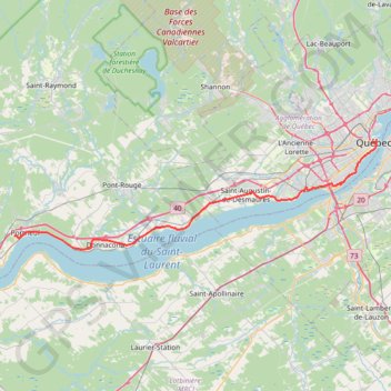
Portneuf - Québec
Saint Lawrence River. #Bike #Portneuf #Québec #SaintLawrence
- Distance: 41.5 mi
- Elevation gain: 1,795 ft
- Maximum elevation: 295 ft
- Elevation loss: 1,690 ft
- Minimum elevation: 0 ft
Interactive trail map
Trail profile
- Distance: 41.5 mi
- Elevation gain: 1,795 ft
- Maximum elevation: 295 ft
- Elevation loss: 1,690 ft
- Minimum elevation: 0 ft
About this trail
Name: Portneuf - Québec trail, distance, elevation, map, profile, GPS track
Coordinates: 46.66972 -71.90563 46.81389 -71.20285
Other hiking, mountain biking, running and outdoor activity trails
Click on a trail to view its statistics, map and profile.
Québec - Saint-Jean-Port-Joli
Canada > Quebec > Urban agglomeration of Québec > Quebec
Saint Lawrence River. #Bike #Québec #SaintJeanPortJoli
Distance: 59.2 mi • Elevation gain: 1,562 ft • Maximum elevation: 269 ft
Trois-Rivières - Québec
Canada > Quebec > Trois-Rivières
#Bike
Distance: 86.0 mi • Elevation gain: 2,749 ft • Maximum elevation: 354 ft