Import a GPX file

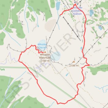
Whistler Mountain - High Note Trail

#Hiking #Loop #Whistler

  • Distance: 3.9 mi
  • Elevation gain: 892 ft
  • Maximum elevation: 7,139 ft
  • Elevation loss: 2,198 ft
  • Minimum elevation: 5,823 ft

Interactive trail map

Trail profile

  • Distance: 3.9 mi
  • Elevation gain: 892 ft
  • Maximum elevation: 7,139 ft
  • Elevation loss: 2,198 ft
  • Minimum elevation: 5,823 ft

About this trail

Other hiking, mountain biking, running and outdoor activity trails

Click on a trail to view its statistics, map and profile.

Cheakamus River and Lillooet River

Canada > British Columbia > Squamish-Lillooet Regional District > Area D (Elaho/Garibaldi)

Bikepack from Daisy Lake along Cheakamus River and Lillooet River via Alta Lake, Whistler, Green Lake, Shadow Lake, Nairn Falls, One Mile Lake and Pemberton. #Bike #Nature #River #Lake #Mountain #Forest

Distance: 52.6 mi • Elevation gain: 4,045 ft • Maximum elevation: 2,474 ft

Vancouver - Golden

Canada > British Columbia > Metro Vancouver Regional District > Vancouver

#Bike #Vancouver #Golden

Distance: 514.2 mi • Elevation gain: 30,761 ft • Maximum elevation: 4,419 ft

Gear up for your next adventure:

📡Handheld GPS Device - Reliable handheld GPS for outdoor navigation
🔋Rechargeable Batteries - Power up your outdoor devices
🛡️Insect Repellent - Protection against bugs during outdoor activities
📦Dry Bags Set - Waterproof storage for electronics and clothes
🔥Plasma Lighters - Windproof lighters that work in any weather condition

As an Amazon Associate, this site earns from qualifying purchases at no extra cost to you.