Thank you for supporting this site ❤️
Make a donation
Make a donation
Gear up for your next adventure:
As an Amazon Associate, this site earns from qualifying purchases at no extra cost to you.
Sightseeing Calgary
Interactive trail map
Thank you for supporting this site ❤️
Make a donation
Make a donation
Gear up for your next adventure:
As an Amazon Associate, this site earns from qualifying purchases at no extra cost to you.
Trail profile
- Distance: 14.2 mi
- Elevation gain: 1,119 ft
- Maximum elevation: 3,632 ft
- Elevation loss: 1,119 ft
- Minimum elevation: 3,422 ft
Thank you for supporting this site ❤️
Make a donation
Make a donation
Gear up for your next adventure:
As an Amazon Associate, this site earns from qualifying purchases at no extra cost to you.
About this trail
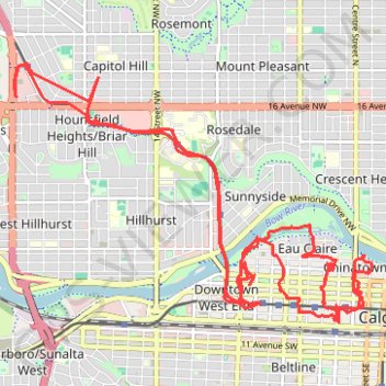
Name: Sightseeing Calgary trail, distance, elevation, map, profile, GPS track
Start: 24 Street NW, Banff Trail, Calgary, Alberta, T2M 3Y7, Canada (51.06796 -114.11744)
End: 24 Street NW, Banff Trail, Calgary, Alberta, T2M 3Y7, Canada (51.06783 -114.11728)
Coordinates: 51.04499 -114.11757 51.07123 -114.05989
Thank you for supporting this site ❤️
Make a donation
Make a donation
Gear up for your next adventure:
As an Amazon Associate, this site earns from qualifying purchases at no extra cost to you.