Make a donation
Gear up for your next adventure:
As an Amazon Associate, this site earns from qualifying purchases at no extra cost to you.
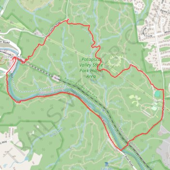
Patapsco Valley State Park - Hilton Area Loop Hike
- Distance: 4.0 mi
- Elevation gain: 597 ft
- Maximum elevation: 400 ft
- Elevation loss: 597 ft
- Minimum elevation: 59 ft
- Moving time: 1 h 30 m
- Moving speed: 2.7 mph
- Maximum speed: 4.0 mph
- Total time: 2 h 10 m
- Global speed: 1.8 mph
Interactive trail map
Make a donation
Gear up for your next adventure:
As an Amazon Associate, this site earns from qualifying purchases at no extra cost to you.
Trail profile
- Distance: 4.0 mi
- Elevation gain: 597 ft
- Maximum elevation: 400 ft
- Elevation loss: 597 ft
- Minimum elevation: 59 ft
- Moving time: 1 h 30 m
- Moving speed: 2.7 mph
- Maximum speed: 4.0 mph
- Total time: 2 h 10 m
- Global speed: 1.8 mph
Make a donation
Gear up for your next adventure:
As an Amazon Associate, this site earns from qualifying purchases at no extra cost to you.
About this trail
Name: Patapsco Valley State Park - Hilton Area Loop Hike trail, distance, elevation, map, profile, GPS track
Coordinates: 39.24101 -76.76549 39.25491 -76.74403
Topography: Baltimore County topographic map, elevation, terrain
Make a donation
Gear up for your next adventure:
As an Amazon Associate, this site earns from qualifying purchases at no extra cost to you.
Other hiking, mountain biking, running and outdoor activity trails
Click on a trail to view its statistics, map and profile.
Cascade Falls Loop Trail in Patapsco Valley State Park
United States > Maryland > Howard County > Ilchester
The Cascade Falls Loop Trail is an enjoyable and moderate hike known for its picturesque landscapes and water features. Along the route, hikers can admire several small waterfalls, including the stunning Cascade Falls itself, which is easily accessible and offers a tranquil pool at its base. The trail also…
Distance: 2.4 mi • Elevation gain: 381 ft • Maximum elevation: 394 ft
St. Mary’s College and Chapel Ruins Loop in Patapsco Valley State Park Ilchester Area
United States > Maryland > Howard County > Ilchester
The St. Mary’s College and Chapel Ruins Loop offers hikers a unique blend of nature and history, showcasing the remnants of a once-grand seminary that dates back to the late 19th century. As you walk along the trail, you’ll encounter intriguing ruins, including stone remnants and a striking metal cross,…
Distance: 2.1 mi • Elevation gain: 269 ft • Maximum elevation: 381 ft
Patapsco Valley State Park Ilchester Area Loop
United States > Maryland > Howard County > Ilchester
Distance: 5.6 mi • Elevation gain: 1,033 ft • Maximum elevation: 358 ft
Cascade Falls Loop Trail in Patapsco Valley State Park
United States > Maryland > Howard County > Elkridge
Distance: 3.9 mi • Elevation gain: 407 ft • Maximum elevation: 384 ft
Make a donation
Gear up for your next adventure:
As an Amazon Associate, this site earns from qualifying purchases at no extra cost to you.
Patapsco Valley State Park Hilton Area Loop
United States > Maryland > Baltimore County > Catonsville
Distance: 4.3 mi • Elevation gain: 617 ft • Maximum elevation: 404 ft
Patapsco Valley State Park trails
United States > Maryland > Baltimore County > Catonsville
Distance: 4.4 mi • Elevation gain: 423 ft • Maximum elevation: 390 ft
Patapsco Valley State Park Hilton Area Loop Hike
United States > Maryland > Baltimore County > Catonsville
Distance: 4.4 mi • Elevation gain: 594 ft • Maximum elevation: 404 ft
Patapsco Valley State Park - Horse Farm Area
United States > Maryland > Howard County > Ellicott City
Distance: 8.1 mi • Elevation gain: 787 ft • Maximum elevation: 371 ft
Make a donation
Gear up for your next adventure:
As an Amazon Associate, this site earns from qualifying purchases at no extra cost to you.
Patapsco Valley State Park Hilton Area Loop
United States > Maryland > Baltimore County > Catonsville
Distance: 6.2 mi • Elevation gain: 823 ft • Maximum elevation: 410 ft
Patapsco River and Santee Branch Trail loop
United States > Maryland > Baltimore County > Catonsville
Distance: 5.6 mi • Elevation gain: 725 ft • Maximum elevation: 404 ft
Patapsco Valley State Park Ilchester Area
United States > Maryland > Howard County > Ilchester
Morning Hike
Distance: 4.5 mi • Elevation gain: 705 ft • Maximum elevation: 354 ft
Patapsco Valley State Park Hilton Area Loop
United States > Maryland > Howard County > Ilchester
Distance: 6.2 mi • Elevation gain: 896 ft • Maximum elevation: 404 ft
Make a donation
Gear up for your next adventure:
As an Amazon Associate, this site earns from qualifying purchases at no extra cost to you.
Patapsco Valley State Park Hilton Area
United States > Maryland > Baltimore County > Catonsville
Morning Loop Hike
Distance: 6.8 mi • Elevation gain: 768 ft • Maximum elevation: 410 ft
Patapsco Valley State Park Hilton Area
United States > Maryland > Baltimore County > Catonsville
Distance: 5.5 mi • Elevation gain: 787 ft • Maximum elevation: 404 ft
Patapsco Valley State Park
United States > Maryland > Baltimore County > Catonsville
Morning Loop Hike
Distance: 6.1 mi • Elevation gain: 1,050 ft • Maximum elevation: 410 ft
Scouting Old Ilchester
United States > Maryland > Howard County > Ilchester
Morning Hike
Distance: 4.9 mi • Elevation gain: 735 ft • Maximum elevation: 354 ft
Make a donation
Gear up for your next adventure:
As an Amazon Associate, this site earns from qualifying purchases at no extra cost to you.
Morning Hike
United States > Maryland > Baltimore County > Catonsville
Distance: 5.9 mi • Elevation gain: 732 ft • Maximum elevation: 404 ft