St. Mary’s College and Chapel Ruins Loop in Patapsco Valley State Park Ilchester Area
The St. Mary’s College and Chapel Ruins Loop offers hikers a unique blend of nature and history, showcasing the remnants of a once-grand seminary that dates back to the late 19th century. As you walk along the trail, you’ll encounter intriguing ruins, including stone remnants and a striking metal cross, all set against a backdrop of lush forest, which adds a sense of mystery and evokes the area's storied past. #Hiking #Loop #Forest #Nature
- Distance: 2.1 mi
- Elevation gain: 269 ft
- Maximum elevation: 381 ft
- Elevation loss: 262 ft
- Minimum elevation: 167 ft
- Moving time: 59 m 58 s
- Moving speed: 2.1 mph
- Maximum speed: 3.8 mph
- Total time: 1 h 50 m
- Global speed: 1.1 mph
Interactive trail map
Trail profile
- Distance: 2.1 mi
- Elevation gain: 269 ft
- Maximum elevation: 381 ft
- Elevation loss: 262 ft
- Minimum elevation: 167 ft
- Moving time: 59 m 58 s
- Moving speed: 2.1 mph
- Maximum speed: 3.8 mph
- Total time: 1 h 50 m
- Global speed: 1.1 mph
About this trail
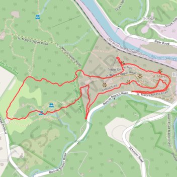
Name: St. Mary’s College and Chapel Ruins Loop in Patapsco Valley State Park Ilchester Area trail, distance, elevation, map, profile, GPS track
Coordinates: 39.24870 -76.77602 39.25177 -76.76548
Topography: Howard County topographic map, elevation, terrain
Other hiking, mountain biking, running and outdoor activity trails
Click on a trail to view its statistics, map and profile.
Patapsco Valley State Park - Hilton Area Loop Hike
United States > Maryland > Baltimore County > Catonsville
Distance: 4.0 mi • Elevation gain: 597 ft • Maximum elevation: 400 ft
Patapsco Valley State Park Ilchester Area Loop
United States > Maryland > Howard County > Ilchester
Distance: 5.6 mi • Elevation gain: 1,033 ft • Maximum elevation: 358 ft
Patapsco Valley State Park Hilton Area
United States > Maryland > Baltimore County > Catonsville
Distance: 5.5 mi • Elevation gain: 787 ft • Maximum elevation: 404 ft
Hike through Patapsco Valley State Park Ilchester Area
United States > Maryland > Howard County > Ilchester
Distance: 5.3 mi • Elevation gain: 915 ft • Maximum elevation: 354 ft
St. Marys's College Ruins and Patapsco Valley State Park Illchester Area hike
United States > Maryland > Howard County > Ilchester
Distance: 3.0 mi • Elevation gain: 499 ft • Maximum elevation: 341 ft
Crossing Patapsco Valley State Park Ilchester Area
United States > Maryland > Howard County > Ilchester
Morning Hike
Distance: 3.6 mi • Elevation gain: 738 ft • Maximum elevation: 361 ft
Patapsco Valley State Park Hilton Area Loop
United States > Maryland > Baltimore County > Catonsville
Distance: 6.2 mi • Elevation gain: 823 ft • Maximum elevation: 410 ft
Patapsco River and Santee Branch Trail loop
United States > Maryland > Baltimore County > Catonsville
Distance: 5.6 mi • Elevation gain: 725 ft • Maximum elevation: 404 ft
Patapsco Valley State Park Ilchester Area
United States > Maryland > Howard County > Ilchester
Morning Hike
Distance: 4.8 mi • Elevation gain: 856 ft • Maximum elevation: 358 ft
Patapsco Valley State Park Ilchester Area
United States > Maryland > Howard County > Ilchester
Morning Hike
Distance: 4.5 mi • Elevation gain: 705 ft • Maximum elevation: 354 ft
Patapsco Valley State Park Hilton Area Loop
United States > Maryland > Howard County > Ilchester
Distance: 6.2 mi • Elevation gain: 896 ft • Maximum elevation: 404 ft
Patapsco Valley State Park Hilton Area
United States > Maryland > Baltimore County > Catonsville
Morning Loop Hike
Distance: 6.8 mi • Elevation gain: 768 ft • Maximum elevation: 410 ft
Old Ilchester Quarry Scouting
United States > Maryland > Howard County > Ilchester
Patapsco Valley State Park - Morning Hike
Distance: 5.2 mi • Elevation gain: 958 ft • Maximum elevation: 354 ft
Scouting Old Ilchester
United States > Maryland > Howard County > Ilchester
Morning Hike
Distance: 4.9 mi • Elevation gain: 837 ft • Maximum elevation: 354 ft
Patapsco Valley State Park
United States > Maryland > Baltimore County > Catonsville
Morning Loop Hike
Distance: 6.1 mi • Elevation gain: 1,050 ft • Maximum elevation: 410 ft
Scouting Old Ilchester
United States > Maryland > Howard County > Ilchester
Morning Hike
Distance: 4.9 mi • Elevation gain: 735 ft • Maximum elevation: 354 ft
Morning Hike
United States > Maryland > Baltimore County > Catonsville
Distance: 5.9 mi • Elevation gain: 732 ft • Maximum elevation: 404 ft