NEW TMB5
Length: 11.58 km (7.195 mi)
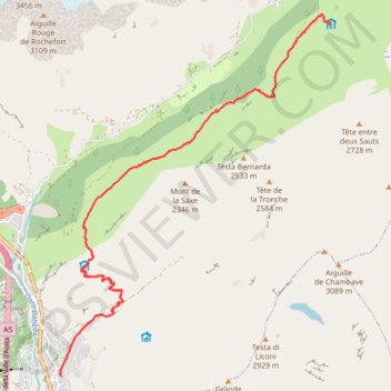
- Distance: 7.3 mi
- Elevation gain: 3,658 ft
- Maximum elevation: 6,696 ft
- Elevation loss: 1,047 ft
- Minimum elevation: 4,016 ft
Interactive trail map
Trail profile
- Distance: 7.3 mi
- Elevation gain: 3,658 ft
- Maximum elevation: 6,696 ft
- Elevation loss: 1,047 ft
- Minimum elevation: 4,016 ft
About this trail
Name: NEW TMB5 trail, distance, elevation, map, profile, GPS track
Start: Via Roma, Pussey, Courmayeur, Aosta Valley, 11013, Italy (45.79135 6.97280)
Coordinates: 45.79135 6.97252 45.84822 7.03359
Other hiking, mountain biking, running and outdoor activity trails
Click on a trail to view its statistics, map and profile.
Ultra-Trail du Mont Blanc (UTMB)
France > Auvergne-Rhône-Alpes > Upper Savoy > Chamonix-Mont-Blanc
Distance: 104.2 mi • Elevation gain: 34,285 ft • Maximum elevation: 8,317 ft
UTMB 2020
France > Auvergne-Rhône-Alpes > Upper Savoy > Chamonix-Mont-Blanc > Les Bossons
Total: 171.3km
Distance: 104.5 mi • Elevation gain: 34,534 ft • Maximum elevation: 8,445 ft
TTdMB-1 Tour Du Mont Blanc - Itinéraire Principal
France > Auvergne-Rhône-Alpes > Upper Savoy > Chamonix-Mont-Blanc
Distance: 103.1 mi • Elevation gain: 34,564 ft • Maximum elevation: 8,323 ft
PT23DS2 Lörrach → Cadaqués
Germany > Baden-Württemberg > Landkreis Lörrach > Lörrach (Kernstadt)
Distance: 652.9 mi • Elevation gain: 43,077 ft • Maximum elevation: 4,938 ft