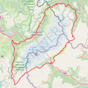
Ultra-Trail du Mont Blanc (UTMB)
- Distance: 104.2 mi
- Elevation gain: 34,285 ft
- Maximum elevation: 8,317 ft
- Elevation loss: 34,288 ft
- Minimum elevation: 2,497 ft
Interactive trail map
Trail profile
- Distance: 104.2 mi
- Elevation gain: 34,285 ft
- Maximum elevation: 8,317 ft
- Elevation loss: 34,288 ft
- Minimum elevation: 2,497 ft
About this trail
Name: Ultra-Trail du Mont Blanc (UTMB) trail, distance, elevation, map, profile, GPS track
Coordinates: 45.69556 6.70667 46.05847 7.12837
Other hiking, mountain biking, running and outdoor activity trails
Click on a trail to view its statistics, map and profile.
Day 01: Les Houches to Auberge du Truc
France > Auvergne-Rhône-Alpes > Upper Savoy > Les Houches > Le Fouilly
Distance: 8.8 mi • Elevation gain: 4,856 ft • Maximum elevation: 6,946 ft
UTMB 2020
France > Auvergne-Rhône-Alpes > Upper Savoy > Chamonix-Mont-Blanc > Les Bossons
Total: 171.3km
Distance: 104.5 mi • Elevation gain: 34,534 ft • Maximum elevation: 8,445 ft
Монблан
France > Auvergne-Rhône-Alpes > Upper Savoy > Saint-Gervais-les-Bains
Distance: 4.9 mi • Elevation gain: 7,490 ft • Maximum elevation: 15,128 ft
Монблан
France > Auvergne-Rhône-Alpes > Upper Savoy > Saint-Gervais-les-Bains
Distance: 4.9 mi • Elevation gain: 7,490 ft • Maximum elevation: 15,128 ft
TTdMB-1 Tour Du Mont Blanc - Itinéraire Principal
France > Auvergne-Rhône-Alpes > Upper Savoy > Chamonix-Mont-Blanc
Distance: 103.1 mi • Elevation gain: 34,564 ft • Maximum elevation: 8,323 ft
PT23DS2 Lörrach → Cadaqués
Germany > Baden-Württemberg > Landkreis Lörrach > Lörrach (Kernstadt)
Distance: 652.9 mi • Elevation gain: 43,077 ft • Maximum elevation: 4,938 ft
NEW TMB5
Italy > Aosta Valley > Courmayeur > Pussey
Length: 11.58 km (7.195 mi)
Distance: 7.3 mi • Elevation gain: 3,658 ft • Maximum elevation: 6,696 ft
(Near) Eglise Notre-Dame de la Gorge to Les Chapieux (Les Chambres du Soleil)
France > Auvergne-Rhône-Alpes > Upper Savoy > Les Contamines-Montjoie > Nant Borrant
Hiking. #Alps
Distance: 9.5 mi • Elevation gain: 4,288 ft • Maximum elevation: 8,163 ft
Mont Blanc par les Grands Mulets
France > Auvergne-Rhône-Alpes > Upper Savoy > Chamonix-Mont-Blanc > Les Bossons
Distance: 15.9 mi • Elevation gain: 12,572 ft • Maximum elevation: 15,745 ft
Tour des Ayères Plaine Joux
France > Auvergne-Rhône-Alpes > Upper Savoy > Passy > Plaine Joux
Distance: 5.2 mi • Elevation gain: 1,296 ft • Maximum elevation: 5,384 ft