Make a donation
Gear up for your next adventure:
As an Amazon Associate, this site earns from qualifying purchases at no extra cost to you.
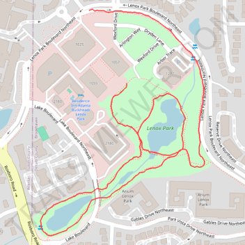
Walk around Lenox Park
- Distance: 1.4 mi
- Elevation gain: 131 ft
- Maximum elevation: 955 ft
- Elevation loss: 144 ft
- Minimum elevation: 889 ft
- Moving time: 27 m 6 s
- Moving speed: 3.1 mph
- Maximum speed: 6.0 mph
- Total time: 27 m 6 s
- Global speed: 3.1 mph
Interactive trail map
Make a donation
Gear up for your next adventure:
As an Amazon Associate, this site earns from qualifying purchases at no extra cost to you.
Trail profile
- Distance: 1.4 mi
- Elevation gain: 131 ft
- Maximum elevation: 955 ft
- Elevation loss: 144 ft
- Minimum elevation: 889 ft
- Moving time: 27 m 6 s
- Moving speed: 3.1 mph
- Maximum speed: 6.0 mph
- Total time: 27 m 6 s
- Global speed: 3.1 mph
Make a donation
Gear up for your next adventure:
As an Amazon Associate, this site earns from qualifying purchases at no extra cost to you.
About this trail
Name: Walk around Lenox Park trail, distance, elevation, map, profile, GPS track
End: 1057, Parkside, Brookhaven, DeKalb County, Georgia, 39319, United States (33.84941 -84.34568)
Coordinates: 33.84575 -84.34817 33.85118 -84.34343
Topography: DeKalb County topographic map, elevation, terrain
Make a donation
Gear up for your next adventure:
As an Amazon Associate, this site earns from qualifying purchases at no extra cost to you.
Other hiking, mountain biking, running and outdoor activity trails
Click on a trail to view its statistics, map and profile.
Atlanta, Lilburn, Yellow River Park, Panola, Jonesboro
United States > Georgia > Fayette County > Peachtree City > Stop
Distance: 208.1 mi • Elevation gain: 13,314 ft • Maximum elevation: 1,109 ft