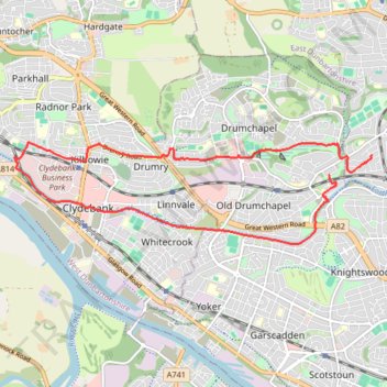
Roads and trails in Clydebank and Drumchapel
- Distance: 7.2 mi
- Elevation gain: 318 ft
- Maximum elevation: 151 ft
- Elevation loss: 256 ft
- Minimum elevation: 23 ft
- Moving time: 38 m 16 s
- Moving speed: 11.2 mph
- Maximum speed: 24.3 mph
- Total time: 39 m 10 s
- Global speed: 11.0 mph
Interactive trail map
Trail profile
- Distance: 7.2 mi
- Elevation gain: 318 ft
- Maximum elevation: 151 ft
- Elevation loss: 256 ft
- Minimum elevation: 23 ft
- Moving time: 38 m 16 s
- Moving speed: 11.2 mph
- Maximum speed: 24.3 mph
- Total time: 39 m 10 s
- Global speed: 11.0 mph
About this trail
Name: Roads and trails in Clydebank and Drumchapel trail, distance, elevation, map, profile, GPS track
Coordinates: 55.89834 -4.41899 55.91047 -4.34284
Other hiking, mountain biking, running and outdoor activity trails
Click on a trail to view its statistics, map and profile.
Trails and roads in Drumchapel
United Kingdom > Scotland > East Dunbartonshire > Glasgow
Distance: 3.4 mi • Elevation gain: 240 ft • Maximum elevation: 167 ft
Johnstone, Scotland to Paisley via Glasgow
United Kingdom > Scotland > Renfrewshire > Johnstone
Bike
Distance: 40.5 mi • Elevation gain: 1,503 ft • Maximum elevation: 174 ft