Long range bike
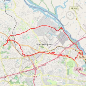
Loop bike from Evans to Savannah River via Savannah River Rapids Park, Augusta Canal Trail, Eisenhower Park and Augusta. #Bike #Loop #City #River
- Distance: 24.7 mi
- Elevation gain: 1,014 ft
- Maximum elevation: 456 ft
- Elevation loss: 1,010 ft
- Minimum elevation: 128 ft
- Moving time: 3 h 19 m
- Moving speed: 7.4 mph
- Maximum speed: 17.2 mph
- Total time: 5 h 48 m
- Global speed: 4.2 mph
Interactive trail map
Trail profile
- Distance: 24.7 mi
- Elevation gain: 1,014 ft
- Maximum elevation: 456 ft
- Elevation loss: 1,010 ft
- Minimum elevation: 128 ft
- Moving time: 3 h 19 m
- Moving speed: 7.4 mph
- Maximum speed: 17.2 mph
- Total time: 5 h 48 m
- Global speed: 4.2 mph
About this trail
Name: Long range bike trail, distance, elevation, map, profile, GPS track
Start: 340, North Belair Road, Evans, Columbia County, Georgia, 30809, United States (33.52611 -82.13788)
Coordinates: 33.50509 -82.13788 33.55389 -82.00249
Topography: Columbia County topographic map, elevation, terrain